You are here: Home > Network List > TA - USArray Transportable Network (new EarthScope stations) Stations List
> Station A36M Sachs Harbour, NT, CAN > Earthquake Result Viewer
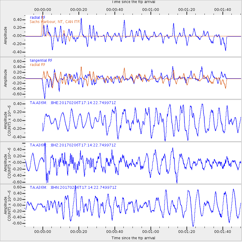
A36M Sachs Harbour, NT, CAN - Earthquake Result Viewer
*The percent match for this event was below the threshold and hence no stack was calculated.
| Earthquake location: |
Western Xizang-India Border Reg. |
| Earthquake latitude/longitude: |
30.7/79.2 |
| Earthquake time(UTC): |
2017/02/06 (037) 17:03:06 GMT |
| Earthquake Depth: |
16 km |
| Earthquake Magnitude: |
5.1 Mwb |
| Earthquake Catalog/Contributor: |
NEIC PDE/us |
|
| Network: |
TA USArray Transportable Network (new EarthScope stations) |
| Station: |
A36M Sachs Harbour, NT, CAN |
| Lat/Lon: |
71.99 N/125.25 W |
| Elevation: |
32 m |
|
| Distance: |
76.2 deg |
| Az: |
7.607 deg |
| Baz: |
338.488 deg |
| Ray Param: |
$rayparam |
*The percent match for this event was below the threshold and hence was not used in the summary stack. |
|
| Radial Match: |
62.36339 % |
| Radial Bump: |
400 |
| Transverse Match: |
73.23747 % |
| Transverse Bump: |
400 |
| SOD ConfigId: |
11737051 |
| Insert Time: |
2019-04-26 18:25:49.709 +0000 |
| GWidth: |
2.5 |
| Max Bumps: |
400 |
| Tol: |
0.001 |
|
Signal To Noise
| Channel | StoN | STA | LTA |
| TA:A36M: :BHZ:20170206T17:14:22.749971Z | 2.4457972 | 3.2156302E-7 | 1.3147574E-7 |
| TA:A36M: :BHN:20170206T17:14:22.749971Z | 0.8633602 | 9.680511E-8 | 1.12125974E-7 |
| TA:A36M: :BHE:20170206T17:14:22.749971Z | 0.8055884 | 1.0733764E-7 | 1.3324129E-7 |
| Arrivals |
| Ps | |
| PpPs | |
| PsPs/PpSs | |


