You are here: Home > Network List > TA - USArray Transportable Network (new EarthScope stations) Stations List
> Station D25K Kavik River, AK, USA > Earthquake Result Viewer
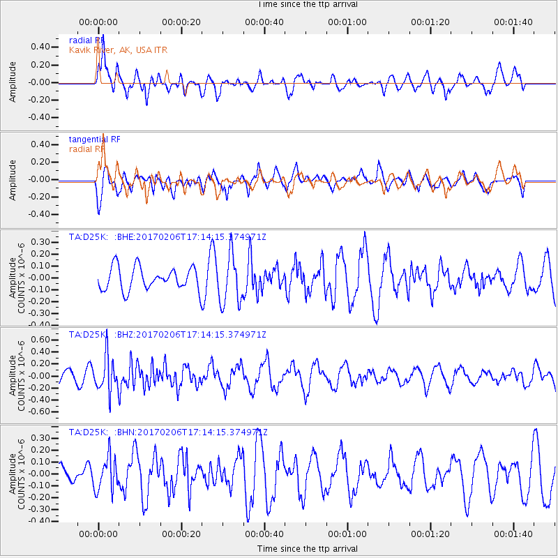
D25K Kavik River, AK, USA - Earthquake Result Viewer
*The percent match for this event was below the threshold and hence no stack was calculated.
| Earthquake location: |
Western Xizang-India Border Reg. |
| Earthquake latitude/longitude: |
30.7/79.2 |
| Earthquake time(UTC): |
2017/02/06 (037) 17:03:06 GMT |
| Earthquake Depth: |
16 km |
| Earthquake Magnitude: |
5.1 Mwb |
| Earthquake Catalog/Contributor: |
NEIC PDE/us |
|
| Network: |
TA USArray Transportable Network (new EarthScope stations) |
| Station: |
D25K Kavik River, AK, USA |
| Lat/Lon: |
69.32 N/146.38 W |
| Elevation: |
770 m |
|
| Distance: |
74.9 deg |
| Az: |
15.22 deg |
| Baz: |
320.436 deg |
| Ray Param: |
$rayparam |
*The percent match for this event was below the threshold and hence was not used in the summary stack. |
|
| Radial Match: |
72.90129 % |
| Radial Bump: |
400 |
| Transverse Match: |
68.53178 % |
| Transverse Bump: |
400 |
| SOD ConfigId: |
11737051 |
| Insert Time: |
2019-04-26 18:25:52.072 +0000 |
| GWidth: |
2.5 |
| Max Bumps: |
400 |
| Tol: |
0.001 |
|
Signal To Noise
| Channel | StoN | STA | LTA |
| TA:D25K: :BHZ:20170206T17:14:15.374971Z | 3.4932873 | 2.978923E-7 | 8.527564E-8 |
| TA:D25K: :BHN:20170206T17:14:15.374971Z | 1.8082963 | 1.4315282E-7 | 7.9164465E-8 |
| TA:D25K: :BHE:20170206T17:14:15.374971Z | 2.1901484 | 2.1142681E-7 | 9.653539E-8 |
| Arrivals |
| Ps | |
| PpPs | |
| PsPs/PpSs | |


