You are here: Home > Network List > CU - Caribbean Network (USGS) Stations List
> Station GRTK Grand Turk, Turks and Caicos Islands > Earthquake Result Viewer
GRTK Grand Turk, Turks and Caicos Islands - Earthquake Result Viewer
| Earthquake location: |
Off Coast Of Central Chile |
| Earthquake latitude/longitude: |
-29.4/-72.1 |
| Earthquake time(UTC): |
2015/11/11 (315) 01:54:37 GMT |
| Earthquake Depth: |
10 km |
| Earthquake Magnitude: |
6.9 MWW, 6.6 MI |
| Earthquake Catalog/Contributor: |
NEIC PDE/NEIC COMCAT |
|
| Network: |
CU Caribbean Network (USGS) |
| Station: |
GRTK Grand Turk, Turks and Caicos Islands |
| Lat/Lon: |
21.51 N/71.13 W |
| Elevation: |
12 m |
|
| Distance: |
50.7 deg |
| Az: |
1.171 deg |
| Baz: |
181.097 deg |
| Ray Param: |
0.067904554 |
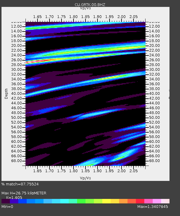
| Estimated Moho Depth: |
26.75 km |
| Estimated Crust Vp/Vs: |
1.61 |
| Assumed Crust Vp: |
4.452 km/s |
| Estimated Crust Vs: |
2.774 km/s |
| Estimated Crust Poisson's Ratio: |
0.18 |
|
| Radial Match: |
87.75524 % |
| Radial Bump: |
360 |
| Transverse Match: |
85.591095 % |
| Transverse Bump: |
400 |
| SOD ConfigId: |
1259291 |
| Insert Time: |
2015-11-25 02:15:51.028 +0000 |
| GWidth: |
2.5 |
| Max Bumps: |
400 |
| Tol: |
0.001 |
|

Signal To Noise
| Channel | StoN | STA | LTA |
| CU:GRTK:00:BHZ:20151111T02:03:06.125009Z | 6.456923 | 3.8739663E-6 | 5.999709E-7 |
| CU:GRTK:00:BH1:20151111T02:03:06.125009Z | 2.671317 | 1.925048E-6 | 7.206363E-7 |
| CU:GRTK:00:BH2:20151111T02:03:06.125009Z | 0.87154907 | 6.5461455E-7 | 7.510932E-7 |
| Arrivals |
| Ps | 3.7 SECOND |
| PpPs | 15 SECOND |
| PsPs/PpSs | 19 SECOND |


