You are here: Home > Network List > CI - Caltech Regional Seismic Network Stations List
> Station LRL Laurel Mtn Radio Fac, Ridgecrest, CA, USA > Earthquake Result Viewer
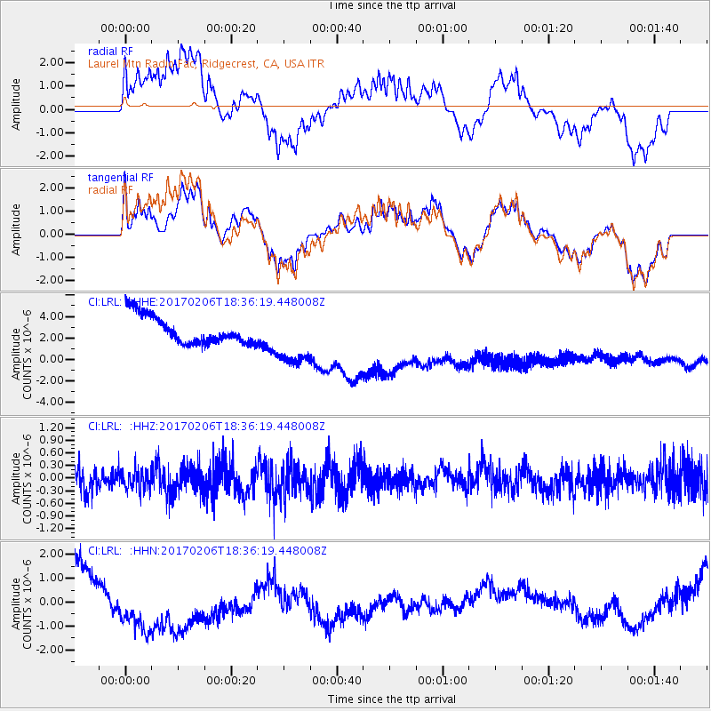
LRL Laurel Mtn Radio Fac, Ridgecrest, CA, USA - Earthquake Result Viewer
*The percent match for this event was below the threshold and hence no stack was calculated.
| Earthquake location: |
Pacific-Antarctic Ridge |
| Earthquake latitude/longitude: |
-57.0/-150.6 |
| Earthquake time(UTC): |
2017/02/06 (037) 18:23:22 GMT |
| Earthquake Depth: |
10 km |
| Earthquake Magnitude: |
5.3 Mwb |
| Earthquake Catalog/Contributor: |
NEIC PDE/us |
|
| Network: |
CI Caltech Regional Seismic Network |
| Station: |
LRL Laurel Mtn Radio Fac, Ridgecrest, CA, USA |
| Lat/Lon: |
35.48 N/117.68 W |
| Elevation: |
1340 m |
|
| Distance: |
96.2 deg |
| Az: |
26.509 deg |
| Baz: |
197.433 deg |
| Ray Param: |
$rayparam |
*The percent match for this event was below the threshold and hence was not used in the summary stack. |
|
| Radial Match: |
67.86822 % |
| Radial Bump: |
400 |
| Transverse Match: |
52.930847 % |
| Transverse Bump: |
400 |
| SOD ConfigId: |
11737051 |
| Insert Time: |
2019-04-26 18:28:52.981 +0000 |
| GWidth: |
2.5 |
| Max Bumps: |
400 |
| Tol: |
0.001 |
|
Signal To Noise
| Channel | StoN | STA | LTA |
| CI:LRL: :HHZ:20170206T18:36:19.448008Z | 0.7105643 | 2.3712882E-7 | 3.33719E-7 |
| CI:LRL: :HHN:20170206T18:36:19.448008Z | 5.2300544 | 2.5048007E-6 | 4.789244E-7 |
| CI:LRL: :HHE:20170206T18:36:19.448008Z | 2.0127778 | 2.6157006E-6 | 1.2995476E-6 |
| Arrivals |
| Ps | |
| PpPs | |
| PsPs/PpSs | |


