You are here: Home > Network List > AV - Alaska Volcano Observatory Stations List
> Station SPCR Ckakachatna River, Mount Spurr, Alaska > Earthquake Result Viewer
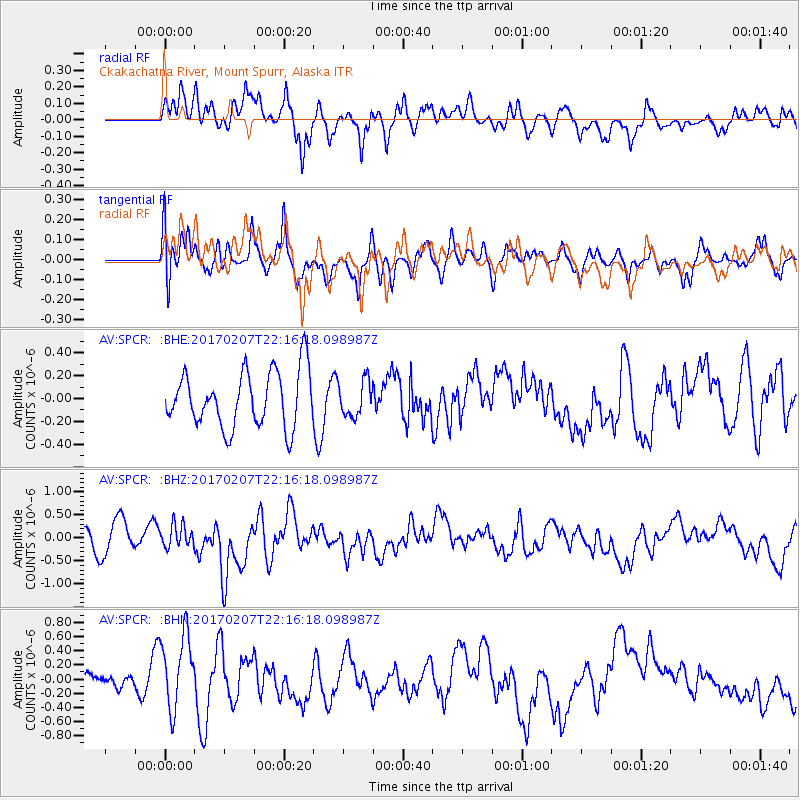
SPCR Ckakachatna River, Mount Spurr, Alaska - Earthquake Result Viewer
*The percent match for this event was below the threshold and hence no stack was calculated.
| Earthquake location: |
Southwestern Pakistan |
| Earthquake latitude/longitude: |
25.2/63.3 |
| Earthquake time(UTC): |
2017/02/07 (038) 22:03:55 GMT |
| Earthquake Depth: |
24 km |
| Earthquake Magnitude: |
6.3 Mww |
| Earthquake Catalog/Contributor: |
NEIC PDE/us |
|
| Network: |
AV Alaska Volcano Observatory |
| Station: |
SPCR Ckakachatna River, Mount Spurr, Alaska |
| Lat/Lon: |
61.20 N/152.21 W |
| Elevation: |
984 m |
|
| Distance: |
89.2 deg |
| Az: |
16.32 deg |
| Baz: |
328.286 deg |
| Ray Param: |
$rayparam |
*The percent match for this event was below the threshold and hence was not used in the summary stack. |
|
| Radial Match: |
62.207455 % |
| Radial Bump: |
400 |
| Transverse Match: |
61.94809 % |
| Transverse Bump: |
400 |
| SOD ConfigId: |
11737051 |
| Insert Time: |
2019-04-26 18:33:08.072 +0000 |
| GWidth: |
2.5 |
| Max Bumps: |
400 |
| Tol: |
0.001 |
|
Signal To Noise
| Channel | StoN | STA | LTA |
| AV:SPCR: :BHZ:20170207T22:16:18.098987Z | 0.66584486 | 2.3815471E-7 | 3.5767297E-7 |
| AV:SPCR: :BHN:20170207T22:16:18.098987Z | 3.6820922 | 5.334992E-7 | 1.4489022E-7 |
| AV:SPCR: :BHE:20170207T22:16:18.098987Z | 0.61896956 | 1.5108647E-7 | 2.4409354E-7 |
| Arrivals |
| Ps | |
| PpPs | |
| PsPs/PpSs | |


