You are here: Home > Network List > G - GEOSCOPE Stations List
> Station MPG Montagne des Peres, French Guyana > Earthquake Result Viewer
MPG Montagne des Peres, French Guyana - Earthquake Result Viewer
| Earthquake location: |
Off Coast Of Central Chile |
| Earthquake latitude/longitude: |
-29.4/-72.1 |
| Earthquake time(UTC): |
2015/11/11 (315) 01:54:37 GMT |
| Earthquake Depth: |
10 km |
| Earthquake Magnitude: |
6.9 MWW, 6.6 MI |
| Earthquake Catalog/Contributor: |
NEIC PDE/NEIC COMCAT |
|
| Network: |
G GEOSCOPE |
| Station: |
MPG Montagne des Peres, French Guyana |
| Lat/Lon: |
5.11 N/52.64 W |
| Elevation: |
147 m |
|
| Distance: |
39.1 deg |
| Az: |
31.743 deg |
| Baz: |
207.434 deg |
| Ray Param: |
0.07517478 |
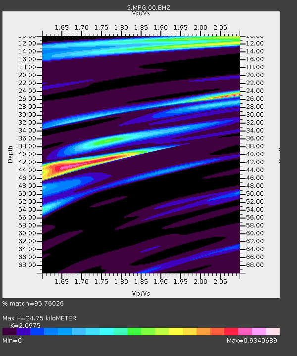
| Estimated Moho Depth: |
24.75 km |
| Estimated Crust Vp/Vs: |
2.10 |
| Assumed Crust Vp: |
6.472 km/s |
| Estimated Crust Vs: |
3.086 km/s |
| Estimated Crust Poisson's Ratio: |
0.35 |
|
| Radial Match: |
95.76026 % |
| Radial Bump: |
262 |
| Transverse Match: |
83.941414 % |
| Transverse Bump: |
400 |
| SOD ConfigId: |
1259291 |
| Insert Time: |
2015-11-25 02:16:34.530 +0000 |
| GWidth: |
2.5 |
| Max Bumps: |
400 |
| Tol: |
0.001 |
|

Signal To Noise
| Channel | StoN | STA | LTA |
| G:MPG:00:BHZ:20151111T02:01:34.250009Z | 27.858923 | 4.645606E-6 | 1.667547E-7 |
| G:MPG:00:BHN:20151111T02:01:34.250009Z | 16.410147 | 2.3886528E-6 | 1.455595E-7 |
| G:MPG:00:BHE:20151111T02:01:34.250009Z | 6.503275 | 9.799727E-7 | 1.506891E-7 |
| Arrivals |
| Ps | 4.5 SECOND |
| PpPs | 11 SECOND |
| PsPs/PpSs | 16 SECOND |


