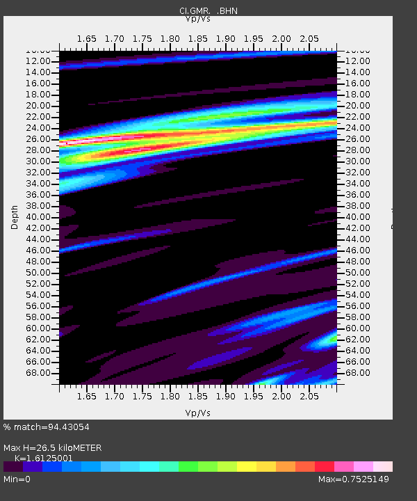
GMR Granite Mountains Research Center - Earthquake Result Viewer
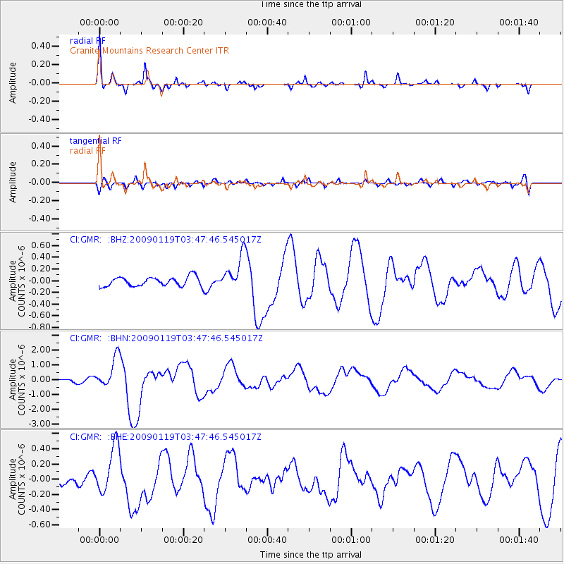
Earthquake location: Southeast Of Loyalty Islands
Earthquake latitude/longitude: -22.6/170.9
Earthquake time(UTC): 2009/01/19 (019) 03:35:18 GMT
Earthquake Depth: 12 km
Earthquake Magnitude: 5.7 MB, 6.4 MS, 6.5 MW, 6.5 MW
Earthquake Catalog/Contributor: WHDF/NEIC
Network: CI Caltech Regional Seismic Network
Station: GMR Granite Mountains Research Center
Lat/Lon: 34.78 N/115.66 W
Elevation: 1326 m
Distance: 90.0 deg
Az: 52.083 deg
Baz: 242.346 deg
Ray Param: 0.041704215
Estimated Moho Depth: 26.5 km
Estimated Crust Vp/Vs: 1.61
Assumed Crust Vp: 6.276 km/s
Estimated Crust Vs: 3.892 km/s
Estimated Crust Poisson's Ratio: 0.19
Radial Match: 94.43054 %
Radial Bump: 301
Transverse Match: 63.47821 %
Transverse Bump: 400
SOD ConfigId: 2658
Insert Time: 2010-03-05 21:59:22.578 +0000
GWidth: 2.5
Max Bumps: 400
Tol: 0.001

Signal To Noise

ChannelStoNSTALTA
CI:GMR: :BHN:20090119T03:47:46.545017Z5.6843521.0880467E-61.9141086E-7
CI:GMR: :BHE:20090119T03:47:46.545017Z2.1374853.2962052E-71.5420952E-7
CI:GMR: :BHZ:20090119T03:47:46.545017Z4.04482463.1584807E-77.808696E-8
Arrivals
Ps2.6 SECOND
PpPs11 SECOND
PsPs/PpSs13 SECOND