You are here: Home > Network List > IU - Global Seismograph Network (GSN - IRIS/USGS) Stations List
> Station KMBO Kilima Mbogo, Kenya > Earthquake Result Viewer
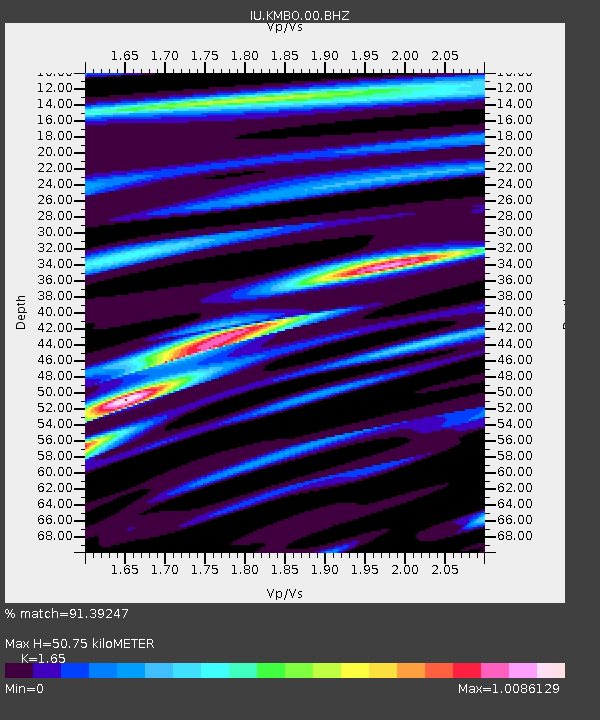
KMBO Kilima Mbogo, Kenya - Earthquake Result Viewer
| Earthquake location: |
Southwestern Pakistan |
| Earthquake latitude/longitude: |
25.2/63.3 |
| Earthquake time(UTC): |
2017/02/07 (038) 22:03:55 GMT |
| Earthquake Depth: |
24 km |
| Earthquake Magnitude: |
6.3 Mww |
| Earthquake Catalog/Contributor: |
NEIC PDE/us |
|
| Network: |
IU Global Seismograph Network (GSN - IRIS/USGS) |
| Station: |
KMBO Kilima Mbogo, Kenya |
| Lat/Lon: |
1.13 S/37.25 E |
| Elevation: |
1950 m |
|
| Distance: |
36.3 deg |
| Az: |
227.748 deg |
| Baz: |
42.12 deg |
| Ray Param: |
0.07671128 |
| Estimated Moho Depth: |
50.75 km |
| Estimated Crust Vp/Vs: |
1.65 |
| Assumed Crust Vp: |
6.601 km/s |
| Estimated Crust Vs: |
4.0 km/s |
| Estimated Crust Poisson's Ratio: |
0.21 |
|
| Radial Match: |
91.39247 % |
| Radial Bump: |
240 |
| Transverse Match: |
80.15708 % |
| Transverse Bump: |
343 |
| SOD ConfigId: |
11737051 |
| Insert Time: |
2019-04-26 18:34:25.542 +0000 |
| GWidth: |
2.5 |
| Max Bumps: |
400 |
| Tol: |
0.001 |
|

Signal To Noise
| Channel | StoN | STA | LTA |
| IU:KMBO:00:BHZ:20170207T22:10:26.769Z | 5.9423876 | 5.4745675E-7 | 9.212741E-8 |
| IU:KMBO:00:BH1:20170207T22:10:26.769Z | 5.6319838 | 2.7262362E-7 | 4.8406324E-8 |
| IU:KMBO:00:BH2:20170207T22:10:26.769Z | 5.610022 | 3.2296617E-7 | 5.7569505E-8 |
| Arrivals |
| Ps | 5.4 SECOND |
| PpPs | 19 SECOND |
| PsPs/PpSs | 24 SECOND |


