You are here: Home > Network List > GS - US Geological Survey Networks Stations List
> Station DEC06 Boomer, Decatur, IL, USA > Earthquake Result Viewer
DEC06 Boomer, Decatur, IL, USA - Earthquake Result Viewer

| Earthquake location: |
Off Coast Of Central Chile |
| Earthquake latitude/longitude: |
-29.4/-72.1 |
| Earthquake time(UTC): |
2015/11/11 (315) 01:54:37 GMT |
| Earthquake Depth: |
10 km |
| Earthquake Magnitude: |
6.9 MWW, 6.6 MI |
| Earthquake Catalog/Contributor: |
NEIC PDE/NEIC COMCAT |
|
| Network: |
GS US Geological Survey Networks |
| Station: |
DEC06 Boomer, Decatur, IL, USA |
| Lat/Lon: |
39.90 N/88.95 W |
| Elevation: |
215 m |
|
| Distance: |
70.7 deg |
| Az: |
346.344 deg |
| Baz: |
164.473 deg |
| Ray Param: |
0.054783545 |
| Estimated Moho Depth: |
33.5 km |
| Estimated Crust Vp/Vs: |
1.62 |
| Assumed Crust Vp: |
6.444 km/s |
| Estimated Crust Vs: |
3.972 km/s |
| Estimated Crust Poisson's Ratio: |
0.19 |
|
| Radial Match: |
85.51585 % |
| Radial Bump: |
400 |
| Transverse Match: |
67.942505 % |
| Transverse Bump: |
400 |
| SOD ConfigId: |
1259291 |
| Insert Time: |
2015-11-25 02:16:58.648 +0000 |
| GWidth: |
2.5 |
| Max Bumps: |
400 |
| Tol: |
0.001 |
|
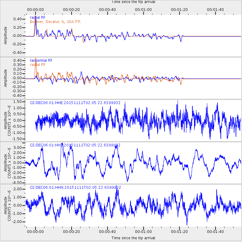
Signal To Noise
| Channel | StoN | STA | LTA |
| GS:DEC06:01:HHZ:20151111T02:05:22.639993Z | 5.6968126 | 1.3895001E-6 | 2.4390832E-7 |
| GS:DEC06:01:HHN:20151111T02:05:22.639993Z | 2.076102 | 8.6545265E-7 | 4.168642E-7 |
| GS:DEC06:01:HHE:20151111T02:05:22.639993Z | 1.6699928 | 5.042748E-7 | 3.0196225E-7 |
| Arrivals |
| Ps | 3.4 SECOND |
| PpPs | 13 SECOND |
| PsPs/PpSs | 16 SECOND |


