You are here: Home > Network List > KO - Kandilli Observatory Digital Broadband Seismic Network Stations List
> Station BALB Balikesir-Turkiye > Earthquake Result Viewer
BALB Balikesir-Turkiye - Earthquake Result Viewer
| Earthquake location: |
Southwestern Pakistan |
| Earthquake latitude/longitude: |
25.2/63.3 |
| Earthquake time(UTC): |
2017/02/07 (038) 22:03:55 GMT |
| Earthquake Depth: |
24 km |
| Earthquake Magnitude: |
6.3 Mww |
| Earthquake Catalog/Contributor: |
NEIC PDE/us |
|
| Network: |
KO Kandilli Observatory Digital Broadband Seismic Network |
| Station: |
BALB Balikesir-Turkiye |
| Lat/Lon: |
39.64 N/27.88 E |
| Elevation: |
120 m |
|
| Distance: |
32.9 deg |
| Az: |
304.654 deg |
| Baz: |
105.186 deg |
| Ray Param: |
0.07841532 |
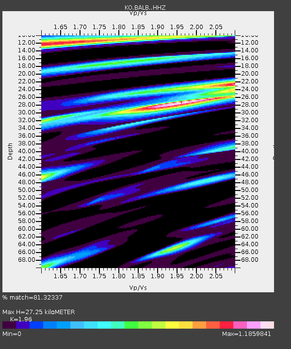
| Estimated Moho Depth: |
27.25 km |
| Estimated Crust Vp/Vs: |
1.96 |
| Assumed Crust Vp: |
6.155 km/s |
| Estimated Crust Vs: |
3.14 km/s |
| Estimated Crust Poisson's Ratio: |
0.32 |
|
| Radial Match: |
81.32337 % |
| Radial Bump: |
400 |
| Transverse Match: |
53.313972 % |
| Transverse Bump: |
400 |
| SOD ConfigId: |
11737051 |
| Insert Time: |
2019-04-26 18:34:39.968 +0000 |
| GWidth: |
2.5 |
| Max Bumps: |
400 |
| Tol: |
0.001 |
|

Signal To Noise
| Channel | StoN | STA | LTA |
| KO:BALB: :HHZ:20170207T22:09:57.490009Z | 4.7854257 | 7.3461155E-7 | 1.5351019E-7 |
| KO:BALB: :HHN:20170207T22:09:57.490009Z | 1.2166662 | 2.1167097E-7 | 1.739762E-7 |
| KO:BALB: :HHE:20170207T22:09:57.490009Z | 1.6669254 | 4.1706372E-7 | 2.5019938E-7 |
| Arrivals |
| Ps | 4.5 SECOND |
| PpPs | 12 SECOND |
| PsPs/PpSs | 17 SECOND |


