You are here: Home > Network List > CI - Caltech Regional Seismic Network Stations List
> Station GMR Granite Mountains Research Center > Earthquake Result Viewer
GMR Granite Mountains Research Center - Earthquake Result Viewer
| Earthquake location: |
Santiago Del Estero Prov., Arg. |
| Earthquake latitude/longitude: |
-26.0/-63.2 |
| Earthquake time(UTC): |
2006/11/13 (317) 01:26:34 GMT |
| Earthquake Depth: |
552 km |
| Earthquake Magnitude: |
6.3 MB, 6.8 MW, 6.8 MW |
| Earthquake Catalog/Contributor: |
WHDF/NEIC |
|
| Network: |
CI Caltech Regional Seismic Network |
| Station: |
GMR Granite Mountains Research Center |
| Lat/Lon: |
34.78 N/115.66 W |
| Elevation: |
1326 m |
|
| Distance: |
78.3 deg |
| Az: |
318.21 deg |
| Baz: |
133.249 deg |
| Ray Param: |
0.048067853 |
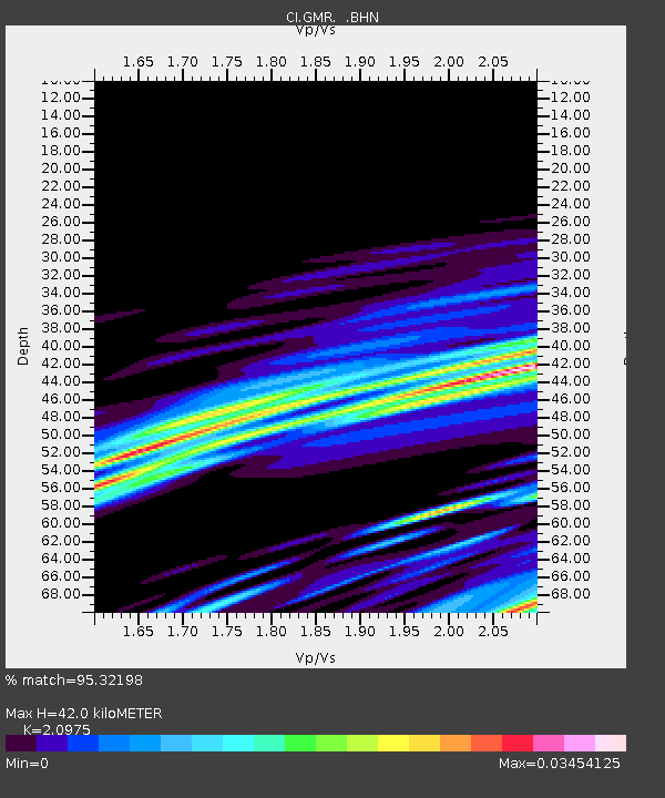
| Estimated Moho Depth: |
42.0 km |
| Estimated Crust Vp/Vs: |
2.10 |
| Assumed Crust Vp: |
6.276 km/s |
| Estimated Crust Vs: |
2.992 km/s |
| Estimated Crust Poisson's Ratio: |
0.35 |
|
| Radial Match: |
95.32198 % |
| Radial Bump: |
128 |
| Transverse Match: |
34.20855 % |
| Transverse Bump: |
299 |
| SOD ConfigId: |
2564 |
| Insert Time: |
2010-03-05 21:59:28.884 +0000 |
| GWidth: |
2.5 |
| Max Bumps: |
400 |
| Tol: |
0.001 |
|
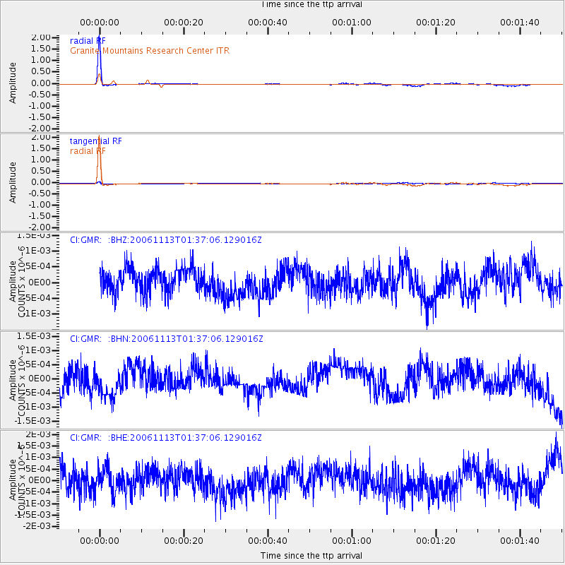
Signal To Noise
| Channel | StoN | STA | LTA |
| CI:GMR: :BHN:20061113T01:37:06.129016Z | 1.4772385 | 5.510416E-10 | 3.730214E-10 |
| CI:GMR: :BHE:20061113T01:37:06.129016Z | 1.0839956 | 5.2315263E-10 | 4.826151E-10 |
| CI:GMR: :BHZ:20061113T01:37:06.129016Z | 1.6449863 | 5.7905075E-10 | 3.5200948E-10 |
| Arrivals |
| Ps | 7.5 SECOND |
| PpPs | 20 SECOND |
| PsPs/PpSs | 28 SECOND |


