You are here: Home > Network List > TA - USArray Transportable Network (new EarthScope stations) Stations List
> Station F21K Alatna River, AK, USA > Earthquake Result Viewer
F21K Alatna River, AK, USA - Earthquake Result Viewer
| Earthquake location: |
Southwestern Pakistan |
| Earthquake latitude/longitude: |
25.2/63.3 |
| Earthquake time(UTC): |
2017/02/07 (038) 22:03:55 GMT |
| Earthquake Depth: |
24 km |
| Earthquake Magnitude: |
6.3 Mww |
| Earthquake Catalog/Contributor: |
NEIC PDE/us |
|
| Network: |
TA USArray Transportable Network (new EarthScope stations) |
| Station: |
F21K Alatna River, AK, USA |
| Lat/Lon: |
67.22 N/153.48 W |
| Elevation: |
597 m |
|
| Distance: |
83.8 deg |
| Az: |
13.549 deg |
| Baz: |
326.971 deg |
| Ray Param: |
0.04587852 |
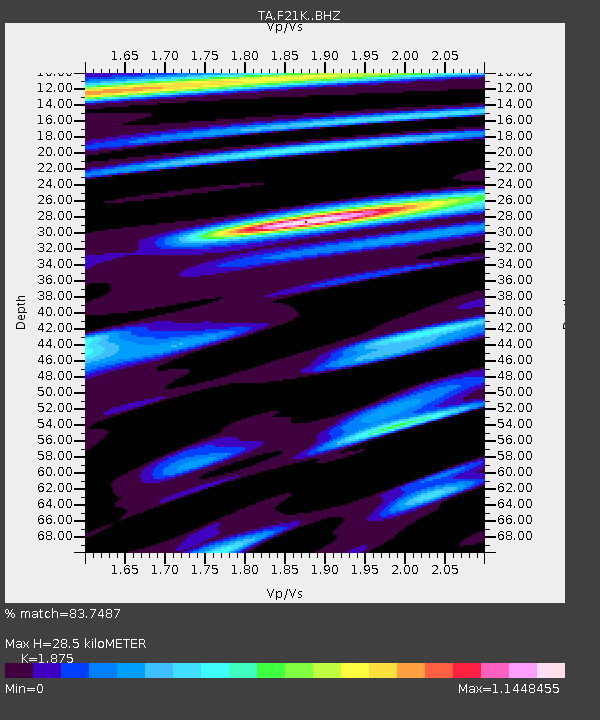
| Estimated Moho Depth: |
28.5 km |
| Estimated Crust Vp/Vs: |
1.88 |
| Assumed Crust Vp: |
6.455 km/s |
| Estimated Crust Vs: |
3.443 km/s |
| Estimated Crust Poisson's Ratio: |
0.30 |
|
| Radial Match: |
83.7487 % |
| Radial Bump: |
400 |
| Transverse Match: |
49.85315 % |
| Transverse Bump: |
400 |
| SOD ConfigId: |
11737051 |
| Insert Time: |
2019-04-26 18:35:49.157 +0000 |
| GWidth: |
2.5 |
| Max Bumps: |
400 |
| Tol: |
0.001 |
|

Signal To Noise
| Channel | StoN | STA | LTA |
| TA:F21K: :BHZ:20170207T22:15:51.725024Z | 4.905075 | 5.8850077E-7 | 1.1997794E-7 |
| TA:F21K: :BHN:20170207T22:15:51.725024Z | 0.99849427 | 2.0865843E-7 | 2.0897309E-7 |
| TA:F21K: :BHE:20170207T22:15:51.725024Z | 1.3874506 | 1.7870917E-7 | 1.2880399E-7 |
| Arrivals |
| Ps | 4.0 SECOND |
| PpPs | 12 SECOND |
| PsPs/PpSs | 16 SECOND |


