You are here: Home > Network List > TA - USArray Transportable Network (new EarthScope stations) Stations List
> Station F26K Sheenjek River, AK, USA > Earthquake Result Viewer
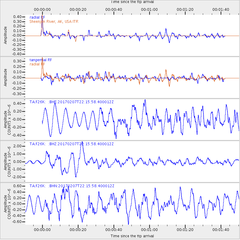
F26K Sheenjek River, AK, USA - Earthquake Result Viewer
*The percent match for this event was below the threshold and hence no stack was calculated.
| Earthquake location: |
Southwestern Pakistan |
| Earthquake latitude/longitude: |
25.2/63.3 |
| Earthquake time(UTC): |
2017/02/07 (038) 22:03:55 GMT |
| Earthquake Depth: |
24 km |
| Earthquake Magnitude: |
6.3 Mww |
| Earthquake Catalog/Contributor: |
NEIC PDE/us |
|
| Network: |
TA USArray Transportable Network (new EarthScope stations) |
| Station: |
F26K Sheenjek River, AK, USA |
| Lat/Lon: |
67.69 N/144.15 W |
| Elevation: |
683 m |
|
| Distance: |
85.2 deg |
| Az: |
10.155 deg |
| Baz: |
335.264 deg |
| Ray Param: |
$rayparam |
*The percent match for this event was below the threshold and hence was not used in the summary stack. |
|
| Radial Match: |
74.59485 % |
| Radial Bump: |
400 |
| Transverse Match: |
55.36039 % |
| Transverse Bump: |
400 |
| SOD ConfigId: |
11737051 |
| Insert Time: |
2019-04-26 18:35:51.224 +0000 |
| GWidth: |
2.5 |
| Max Bumps: |
400 |
| Tol: |
0.001 |
|
Signal To Noise
| Channel | StoN | STA | LTA |
| TA:F26K: :BHZ:20170207T22:15:58.400012Z | 3.7804081 | 6.4593695E-7 | 1.7086434E-7 |
| TA:F26K: :BHN:20170207T22:15:58.400012Z | 0.9444314 | 2.204953E-7 | 2.3346884E-7 |
| TA:F26K: :BHE:20170207T22:15:58.400012Z | 0.8767554 | 1.8116641E-7 | 2.0663279E-7 |
| Arrivals |
| Ps | |
| PpPs | |
| PsPs/PpSs | |


