You are here: Home > Network List > XW17 - Broadband seismic experiment in NE Uganda to investigate plume-lithosphere inter Stations List
> Station GULU Bungatira Sub-County Offices > Earthquake Result Viewer
GULU Bungatira Sub-County Offices - Earthquake Result Viewer
| Earthquake location: |
Southwestern Pakistan |
| Earthquake latitude/longitude: |
25.2/63.3 |
| Earthquake time(UTC): |
2017/02/07 (038) 22:03:55 GMT |
| Earthquake Depth: |
24 km |
| Earthquake Magnitude: |
6.3 Mww |
| Earthquake Catalog/Contributor: |
NEIC PDE/us |
|
| Network: |
XW Broadband seismic experiment in NE Uganda to investigate plume-lithosphere inter |
| Station: |
GULU Bungatira Sub-County Offices |
| Lat/Lon: |
2.88 N/32.28 E |
| Elevation: |
1059 m |
|
| Distance: |
37.2 deg |
| Az: |
238.3 deg |
| Baz: |
50.509 deg |
| Ray Param: |
0.0762486 |
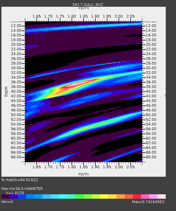
| Estimated Moho Depth: |
36.5 km |
| Estimated Crust Vp/Vs: |
1.82 |
| Assumed Crust Vp: |
6.642 km/s |
| Estimated Crust Vs: |
3.644 km/s |
| Estimated Crust Poisson's Ratio: |
0.28 |
|
| Radial Match: |
94.91922 % |
| Radial Bump: |
238 |
| Transverse Match: |
50.88386 % |
| Transverse Bump: |
400 |
| SOD ConfigId: |
11737051 |
| Insert Time: |
2019-04-26 18:36:39.972 +0000 |
| GWidth: |
2.5 |
| Max Bumps: |
400 |
| Tol: |
0.001 |
|

Signal To Noise
| Channel | StoN | STA | LTA |
| XW:GULU: :BHZ:20170207T22:10:33.995013Z | 4.0738907 | 3.6045378E-7 | 8.8479E-8 |
| XW:GULU: :BHN:20170207T22:10:33.995013Z | 3.0604568 | 1.783106E-7 | 5.826274E-8 |
| XW:GULU: :BHE:20170207T22:10:33.995013Z | 2.856586 | 1.7932133E-7 | 6.27747E-8 |
| Arrivals |
| Ps | 4.9 SECOND |
| PpPs | 14 SECOND |
| PsPs/PpSs | 19 SECOND |


