You are here: Home > Network List > TA - USArray Transportable Network (new EarthScope stations) Stations List
> Station C27K Jago River, AK, USA > Earthquake Result Viewer
C27K Jago River, AK, USA - Earthquake Result Viewer
| Earthquake location: |
Mindanao, Philippines |
| Earthquake latitude/longitude: |
9.9/125.5 |
| Earthquake time(UTC): |
2017/02/10 (041) 14:03:43 GMT |
| Earthquake Depth: |
15 km |
| Earthquake Magnitude: |
6.5 mww |
| Earthquake Catalog/Contributor: |
NEIC PDE/us |
|
| Network: |
TA USArray Transportable Network (new EarthScope stations) |
| Station: |
C27K Jago River, AK, USA |
| Lat/Lon: |
69.63 N/143.71 W |
| Elevation: |
392 m |
|
| Distance: |
81.1 deg |
| Az: |
20.761 deg |
| Baz: |
274.255 deg |
| Ray Param: |
0.047841918 |
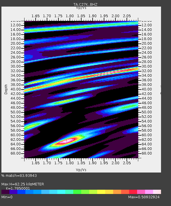
| Estimated Moho Depth: |
62.25 km |
| Estimated Crust Vp/Vs: |
1.79 |
| Assumed Crust Vp: |
6.522 km/s |
| Estimated Crust Vs: |
3.654 km/s |
| Estimated Crust Poisson's Ratio: |
0.27 |
|
| Radial Match: |
83.93943 % |
| Radial Bump: |
400 |
| Transverse Match: |
82.43016 % |
| Transverse Bump: |
400 |
| SOD ConfigId: |
11737051 |
| Insert Time: |
2019-04-26 18:41:47.117 +0000 |
| GWidth: |
2.5 |
| Max Bumps: |
400 |
| Tol: |
0.001 |
|

Signal To Noise
| Channel | StoN | STA | LTA |
| TA:C27K: :BHZ:20170210T14:15:26.875029Z | 2.876968 | 3.362784E-7 | 1.1688638E-7 |
| TA:C27K: :BHN:20170210T14:15:26.875029Z | 0.94974625 | 1.9659689E-7 | 2.0699937E-7 |
| TA:C27K: :BHE:20170210T14:15:26.875029Z | 1.3973372 | 1.9584603E-7 | 1.401566E-7 |
| Arrivals |
| Ps | 7.7 SECOND |
| PpPs | 26 SECOND |
| PsPs/PpSs | 34 SECOND |


