You are here: Home > Network List > TA - USArray Transportable Network (new EarthScope stations) Stations List
> Station E23K Chandalar, AK, USA > Earthquake Result Viewer
E23K Chandalar, AK, USA - Earthquake Result Viewer
| Earthquake location: |
Mindanao, Philippines |
| Earthquake latitude/longitude: |
9.9/125.5 |
| Earthquake time(UTC): |
2017/02/10 (041) 14:03:43 GMT |
| Earthquake Depth: |
15 km |
| Earthquake Magnitude: |
6.5 mww |
| Earthquake Catalog/Contributor: |
NEIC PDE/us |
|
| Network: |
TA USArray Transportable Network (new EarthScope stations) |
| Station: |
E23K Chandalar, AK, USA |
| Lat/Lon: |
68.06 N/149.62 W |
| Elevation: |
1084 m |
|
| Distance: |
79.0 deg |
| Az: |
22.421 deg |
| Baz: |
269.039 deg |
| Ray Param: |
0.04927561 |
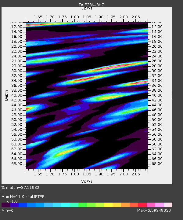
| Estimated Moho Depth: |
11.0 km |
| Estimated Crust Vp/Vs: |
1.60 |
| Assumed Crust Vp: |
6.316 km/s |
| Estimated Crust Vs: |
3.948 km/s |
| Estimated Crust Poisson's Ratio: |
0.18 |
|
| Radial Match: |
87.21932 % |
| Radial Bump: |
400 |
| Transverse Match: |
80.28474 % |
| Transverse Bump: |
400 |
| SOD ConfigId: |
11737051 |
| Insert Time: |
2019-04-26 18:41:50.784 +0000 |
| GWidth: |
2.5 |
| Max Bumps: |
400 |
| Tol: |
0.001 |
|

Signal To Noise
| Channel | StoN | STA | LTA |
| TA:E23K: :BHZ:20170210T14:15:15.600005Z | 2.107602 | 4.1426892E-7 | 1.965594E-7 |
| TA:E23K: :BHN:20170210T14:15:15.600005Z | 0.9517985 | 1.6539224E-7 | 1.7376811E-7 |
| TA:E23K: :BHE:20170210T14:15:15.600005Z | 0.66358507 | 1.01780266E-7 | 1.5337937E-7 |
| Arrivals |
| Ps | 1.1 SECOND |
| PpPs | 4.4 SECOND |
| PsPs/PpSs | 5.5 SECOND |


