You are here: Home > Network List > TA - USArray Transportable Network (new EarthScope stations) Stations List
> Station H22K Ishtalitna Creek, AK, USA > Earthquake Result Viewer
H22K Ishtalitna Creek, AK, USA - Earthquake Result Viewer
| Earthquake location: |
Mindanao, Philippines |
| Earthquake latitude/longitude: |
9.9/125.5 |
| Earthquake time(UTC): |
2017/02/10 (041) 14:03:43 GMT |
| Earthquake Depth: |
15 km |
| Earthquake Magnitude: |
6.5 mww |
| Earthquake Catalog/Contributor: |
NEIC PDE/us |
|
| Network: |
TA USArray Transportable Network (new EarthScope stations) |
| Station: |
H22K Ishtalitna Creek, AK, USA |
| Lat/Lon: |
65.89 N/151.38 W |
| Elevation: |
561 m |
|
| Distance: |
78.2 deg |
| Az: |
24.619 deg |
| Baz: |
267.855 deg |
| Ray Param: |
0.04978539 |
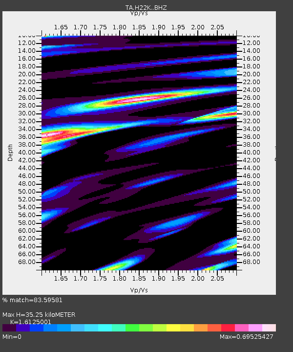
| Estimated Moho Depth: |
35.25 km |
| Estimated Crust Vp/Vs: |
1.61 |
| Assumed Crust Vp: |
6.566 km/s |
| Estimated Crust Vs: |
4.072 km/s |
| Estimated Crust Poisson's Ratio: |
0.19 |
|
| Radial Match: |
83.59581 % |
| Radial Bump: |
400 |
| Transverse Match: |
59.633404 % |
| Transverse Bump: |
400 |
| SOD ConfigId: |
11737051 |
| Insert Time: |
2019-04-26 18:41:56.393 +0000 |
| GWidth: |
2.5 |
| Max Bumps: |
400 |
| Tol: |
0.001 |
|

Signal To Noise
| Channel | StoN | STA | LTA |
| TA:H22K: :BHZ:20170210T14:15:11.475005Z | 2.1833644 | 4.9508947E-7 | 2.2675532E-7 |
| TA:H22K: :BHN:20170210T14:15:11.475005Z | 0.55872613 | 1.3908735E-7 | 2.4893654E-7 |
| TA:H22K: :BHE:20170210T14:15:11.475005Z | 2.8507104 | 3.0376043E-7 | 1.0655605E-7 |
| Arrivals |
| Ps | 3.4 SECOND |
| PpPs | 14 SECOND |
| PsPs/PpSs | 17 SECOND |


