You are here: Home > Network List > AV - Alaska Volcano Observatory Stations List
> Station MAPS Pakushin Southeast, Makushin Volcano, Alaska > Earthquake Result Viewer
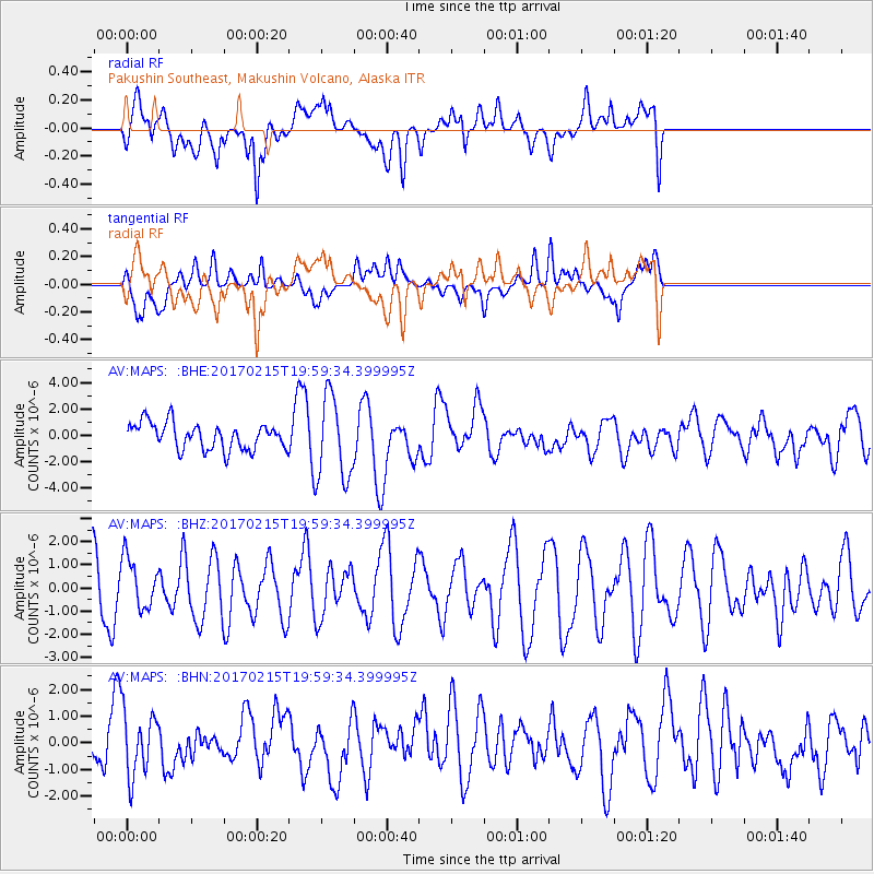
MAPS Pakushin Southeast, Makushin Volcano, Alaska - Earthquake Result Viewer
*The percent match for this event was below the threshold and hence no stack was calculated.
| Earthquake location: |
Northern Sumatra, Indonesia |
| Earthquake latitude/longitude: |
5.3/96.1 |
| Earthquake time(UTC): |
2017/02/15 (046) 19:47:08 GMT |
| Earthquake Depth: |
20 km |
| Earthquake Magnitude: |
5.6 mb |
| Earthquake Catalog/Contributor: |
NEIC PDE/us |
|
| Network: |
AV Alaska Volcano Observatory |
| Station: |
MAPS Pakushin Southeast, Makushin Volcano, Alaska |
| Lat/Lon: |
53.81 N/166.94 W |
| Elevation: |
333 m |
|
| Distance: |
89.9 deg |
| Az: |
36.067 deg |
| Baz: |
278.673 deg |
| Ray Param: |
$rayparam |
*The percent match for this event was below the threshold and hence was not used in the summary stack. |
|
| Radial Match: |
62.59329 % |
| Radial Bump: |
400 |
| Transverse Match: |
46.269714 % |
| Transverse Bump: |
400 |
| SOD ConfigId: |
11737051 |
| Insert Time: |
2019-04-26 18:49:42.452 +0000 |
| GWidth: |
2.5 |
| Max Bumps: |
400 |
| Tol: |
0.001 |
|
Signal To Noise
| Channel | StoN | STA | LTA |
| AV:MAPS: :BHZ:20170215T19:59:34.399995Z | 0.6244254 | 1.0616551E-6 | 1.7002113E-6 |
| AV:MAPS: :BHN:20170215T19:59:34.399995Z | 0.90546334 | 1.1877586E-6 | 1.3117689E-6 |
| AV:MAPS: :BHE:20170215T19:59:34.399995Z | 3.0962906 | 3.0917595E-6 | 9.985366E-7 |
| Arrivals |
| Ps | |
| PpPs | |
| PsPs/PpSs | |


