You are here: Home > Network List > TJ - Tajikistan National Seismic Network Stations List
> Station GARM Garm, Tajikistan > Earthquake Result Viewer
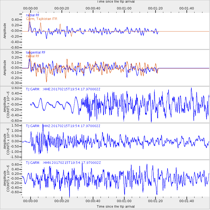
GARM Garm, Tajikistan - Earthquake Result Viewer
*The percent match for this event was below the threshold and hence no stack was calculated.
| Earthquake location: |
Northern Sumatra, Indonesia |
| Earthquake latitude/longitude: |
5.3/96.1 |
| Earthquake time(UTC): |
2017/02/15 (046) 19:47:08 GMT |
| Earthquake Depth: |
20 km |
| Earthquake Magnitude: |
5.6 mb |
| Earthquake Catalog/Contributor: |
NEIC PDE/us |
|
| Network: |
TJ Tajikistan National Seismic Network |
| Station: |
GARM Garm, Tajikistan |
| Lat/Lon: |
39.00 N/70.32 E |
| Elevation: |
1305 m |
|
| Distance: |
40.9 deg |
| Az: |
328.814 deg |
| Baz: |
138.563 deg |
| Ray Param: |
$rayparam |
*The percent match for this event was below the threshold and hence was not used in the summary stack. |
|
| Radial Match: |
57.322437 % |
| Radial Bump: |
400 |
| Transverse Match: |
42.792767 % |
| Transverse Bump: |
400 |
| SOD ConfigId: |
11737051 |
| Insert Time: |
2019-04-26 18:52:28.947 +0000 |
| GWidth: |
2.5 |
| Max Bumps: |
400 |
| Tol: |
0.001 |
|
Signal To Noise
| Channel | StoN | STA | LTA |
| TJ:GARM: :HHZ:20170215T19:54:17.970002Z | 4.0764174 | 4.839806E-7 | 1.1872695E-7 |
| TJ:GARM: :HHN:20170215T19:54:17.970002Z | 1.1006157 | 1.5595091E-7 | 1.4169424E-7 |
| TJ:GARM: :HHE:20170215T19:54:17.970002Z | 1.6953137 | 1.6219106E-7 | 9.567023E-8 |
| Arrivals |
| Ps | |
| PpPs | |
| PsPs/PpSs | |


