You are here: Home > Network List > MB - Montana Regional Seismic Network Stations List
> Station LDM Little Jackson Creek seismic vault > Earthquake Result Viewer
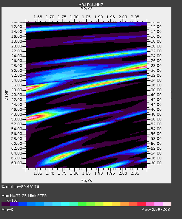
LDM Little Jackson Creek seismic vault - Earthquake Result Viewer
| Earthquake location: |
Jujuy Province, Argentina |
| Earthquake latitude/longitude: |
-23.9/-66.7 |
| Earthquake time(UTC): |
2017/02/18 (049) 12:10:15 GMT |
| Earthquake Depth: |
201 km |
| Earthquake Magnitude: |
6.3 Mww |
| Earthquake Catalog/Contributor: |
NEIC PDE/us |
|
| Network: |
MB Montana Regional Seismic Network |
| Station: |
LDM Little Jackson Creek seismic vault |
| Lat/Lon: |
48.45 N/115.32 W |
| Elevation: |
840 m |
|
| Distance: |
84.2 deg |
| Az: |
329.854 deg |
| Baz: |
136.342 deg |
| Ray Param: |
0.045197293 |
| Estimated Moho Depth: |
37.25 km |
| Estimated Crust Vp/Vs: |
1.60 |
| Assumed Crust Vp: |
6.622 km/s |
| Estimated Crust Vs: |
4.139 km/s |
| Estimated Crust Poisson's Ratio: |
0.18 |
|
| Radial Match: |
80.65176 % |
| Radial Bump: |
400 |
| Transverse Match: |
68.712036 % |
| Transverse Bump: |
400 |
| SOD ConfigId: |
11737051 |
| Insert Time: |
2019-04-26 18:56:55.231 +0000 |
| GWidth: |
2.5 |
| Max Bumps: |
400 |
| Tol: |
0.001 |
|

Signal To Noise
| Channel | StoN | STA | LTA |
| MB:LDM: :HHZ:20170218T12:21:52.62998Z | 2.9809992 | 3.234237E-12 | 1.0849506E-12 |
| MB:LDM: :HHN:20170218T12:21:52.62998Z | 1.3799692 | 1.1697279E-12 | 8.4764785E-13 |
| MB:LDM: :HHE:20170218T12:21:52.62998Z | 1.6438953 | 1.0557926E-12 | 6.422505E-13 |
| Arrivals |
| Ps | 3.5 SECOND |
| PpPs | 14 SECOND |
| PsPs/PpSs | 18 SECOND |


