You are here: Home > Network List > N4 - Central and EAstern US Network Stations List
> Station V55A Morning Dew, Taylorsville, NC, USA > Earthquake Result Viewer
V55A Morning Dew, Taylorsville, NC, USA - Earthquake Result Viewer
| Earthquake location: |
Jujuy Province, Argentina |
| Earthquake latitude/longitude: |
-23.9/-66.7 |
| Earthquake time(UTC): |
2017/02/18 (049) 12:10:15 GMT |
| Earthquake Depth: |
201 km |
| Earthquake Magnitude: |
6.3 Mww |
| Earthquake Catalog/Contributor: |
NEIC PDE/us |
|
| Network: |
N4 Central and EAstern US Network |
| Station: |
V55A Morning Dew, Taylorsville, NC, USA |
| Lat/Lon: |
35.85 N/81.21 W |
| Elevation: |
313 m |
|
| Distance: |
61.0 deg |
| Az: |
346.529 deg |
| Baz: |
164.787 deg |
| Ray Param: |
0.060527217 |
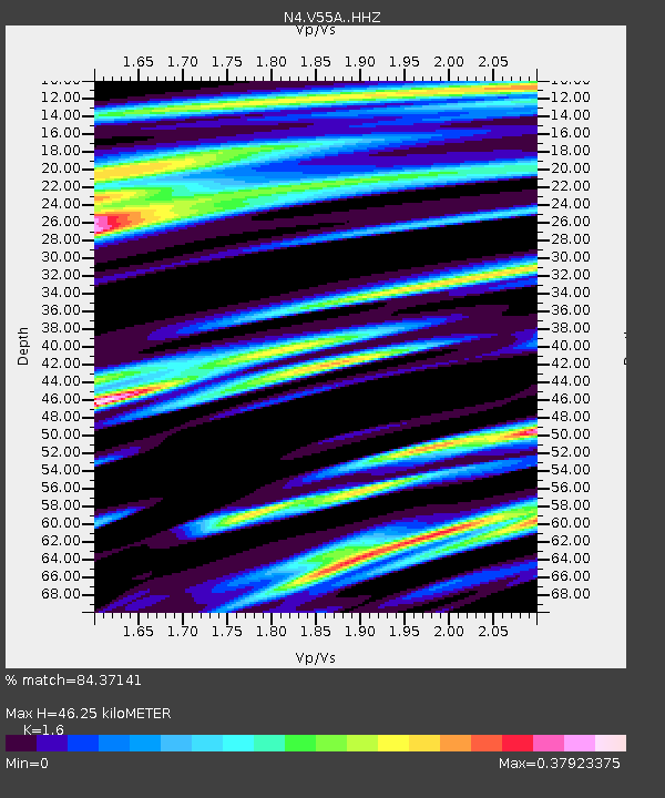
| Estimated Moho Depth: |
46.25 km |
| Estimated Crust Vp/Vs: |
1.60 |
| Assumed Crust Vp: |
6.419 km/s |
| Estimated Crust Vs: |
4.012 km/s |
| Estimated Crust Poisson's Ratio: |
0.18 |
|
| Radial Match: |
84.37141 % |
| Radial Bump: |
304 |
| Transverse Match: |
69.14646 % |
| Transverse Bump: |
352 |
| SOD ConfigId: |
11737051 |
| Insert Time: |
2019-04-26 18:58:25.552 +0000 |
| GWidth: |
2.5 |
| Max Bumps: |
400 |
| Tol: |
0.001 |
|

Signal To Noise
| Channel | StoN | STA | LTA |
| N4:V55A: :HHZ:20170218T12:19:36.759985Z | 6.252433 | 1.698004E-6 | 2.7157492E-7 |
| N4:V55A: :HHN:20170218T12:19:36.759985Z | 3.3191552 | 8.045784E-7 | 2.4240455E-7 |
| N4:V55A: :HHE:20170218T12:19:36.759985Z | 1.6220696 | 2.4953763E-7 | 1.5383904E-7 |
| Arrivals |
| Ps | 4.5 SECOND |
| PpPs | 18 SECOND |
| PsPs/PpSs | 22 SECOND |


