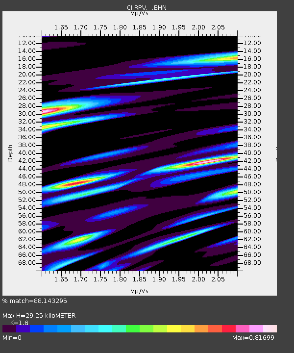
RPV Rancho Palos Verdes, California, USA - Earthquake Result Viewer
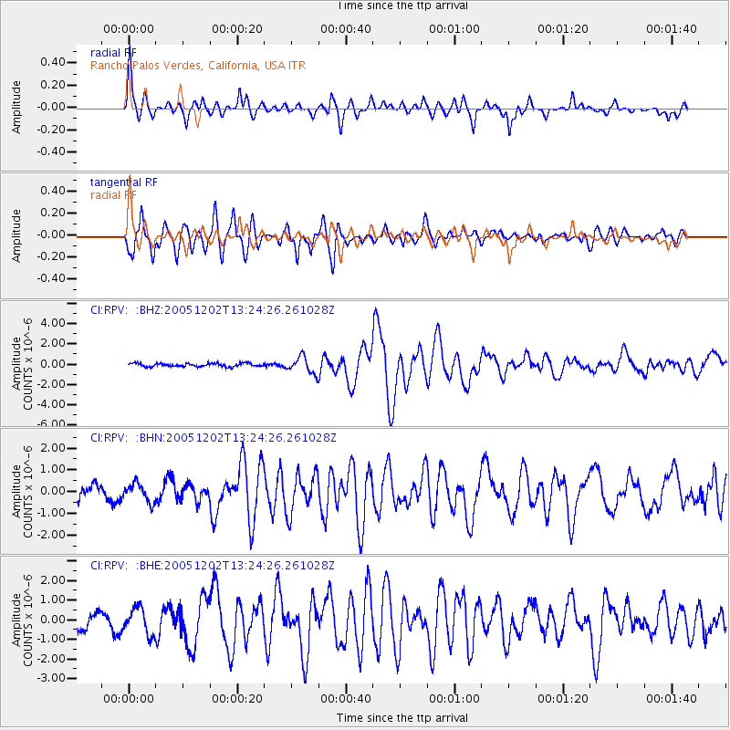
Earthquake location: Near East Coast Of Honshu, Japan
Earthquake latitude/longitude: 38.1/142.1
Earthquake time(UTC): 2005/12/02 (336) 13:13:09 GMT
Earthquake Depth: 29 km
Earthquake Magnitude: 6.1 MB, 6.3 MS, 6.5 MW, 6.4 MW
Earthquake Catalog/Contributor: WHDF/NEIC
Network: CI Caltech Regional Seismic Network
Station: RPV Rancho Palos Verdes, California, USA
Lat/Lon: 33.74 N/118.40 W
Elevation: 64 m
Distance: 76.6 deg
Az: 57.653 deg
Baz: 306.868 deg
Ray Param: 0.050835054
Estimated Moho Depth: 29.25 km
Estimated Crust Vp/Vs: 1.60
Assumed Crust Vp: 6.048 km/s
Estimated Crust Vs: 3.78 km/s
Estimated Crust Poisson's Ratio: 0.18
Radial Match: 88.143295 %
Radial Bump: 400
Transverse Match: 84.28241 %
Transverse Bump: 400
SOD ConfigId: 2422
Insert Time: 2010-03-05 22:02:24.573 +0000
GWidth: 2.5
Max Bumps: 400
Tol: 0.001

Signal To Noise

ChannelStoNSTALTA
CI:RPV: :BHN:20051202T13:24:26.261028Z1.60818844.297773E-72.672431E-7
CI:RPV: :BHE:20051202T13:24:26.261028Z1.55649326.683559E-74.293985E-7
CI:RPV: :BHZ:20051202T13:24:26.261028Z5.0630648.090599E-71.5979649E-7
Arrivals
Ps3.0 SECOND
PpPs12 SECOND
PsPs/PpSs15 SECOND