You are here: Home > Network List > CI - Caltech Regional Seismic Network Stations List
> Station RPV Rancho Palos Verdes, California, USA > Earthquake Result Viewer
RPV Rancho Palos Verdes, California, USA - Earthquake Result Viewer
| Earthquake location: |
Chile-Bolivia Border Region |
| Earthquake latitude/longitude: |
-22.3/-67.9 |
| Earthquake time(UTC): |
2005/11/17 (321) 19:26:56 GMT |
| Earthquake Depth: |
163 km |
| Earthquake Magnitude: |
6.0 MB, 6.9 MW, 6.8 MW |
| Earthquake Catalog/Contributor: |
WHDF/NEIC |
|
| Network: |
CI Caltech Regional Seismic Network |
| Station: |
RPV Rancho Palos Verdes, California, USA |
| Lat/Lon: |
33.74 N/118.40 W |
| Elevation: |
64 m |
|
| Distance: |
73.6 deg |
| Az: |
317.911 deg |
| Baz: |
131.851 deg |
| Ray Param: |
0.052450914 |
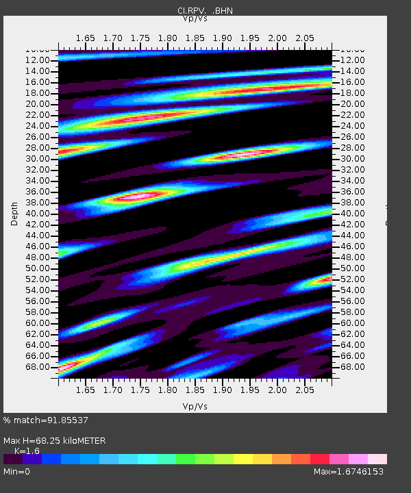
| Estimated Moho Depth: |
68.25 km |
| Estimated Crust Vp/Vs: |
1.60 |
| Assumed Crust Vp: |
6.048 km/s |
| Estimated Crust Vs: |
3.78 km/s |
| Estimated Crust Poisson's Ratio: |
0.18 |
|
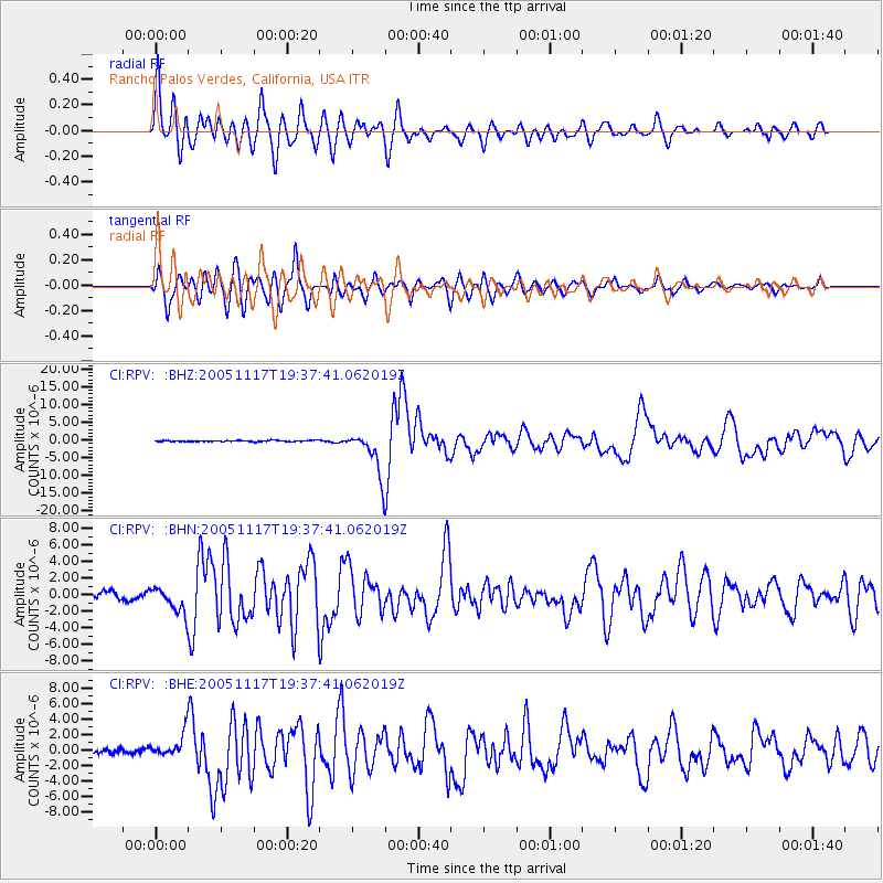
| Radial Match: |
91.85537 % |
| Radial Bump: |
400 |
| Transverse Match: |
85.48261 % |
| Transverse Bump: |
400 |
| SOD ConfigId: |
2422 |
| Insert Time: |
2010-03-05 22:02:26.014 +0000 |
| GWidth: |
2.5 |
| Max Bumps: |
400 |
| Tol: |
0.001 |
|
Signal To Noise
| Channel | StoN | STA | LTA |
| CI:RPV: :BHN:20051117T19:37:41.062019Z | 5.1560626 | 1.6218112E-6 | 3.145445E-7 |
| CI:RPV: :BHE:20051117T19:37:41.062019Z | 4.9206514 | 1.6003838E-6 | 3.252382E-7 |
| CI:RPV: :BHZ:20051117T19:37:41.062019Z | 35.672096 | 6.1650076E-6 | 1.7282439E-7 |
| Arrivals |
| Ps | 7.0 SECOND |
| PpPs | 28 SECOND |
| PsPs/PpSs | 35 SECOND |


