You are here: Home > Network List > PR - Puerto Rico Seismic Network (PRSN) & Puerto Rico Strong Motion Program (PRSMP) Stations List
> Station CRPR Cabo Rojo, Puerto Rico(T3K97) > Earthquake Result Viewer
CRPR Cabo Rojo, Puerto Rico(T3K97) - Earthquake Result Viewer
| Earthquake location: |
Jujuy Province, Argentina |
| Earthquake latitude/longitude: |
-23.9/-66.7 |
| Earthquake time(UTC): |
2017/02/18 (049) 12:10:15 GMT |
| Earthquake Depth: |
201 km |
| Earthquake Magnitude: |
6.3 Mww |
| Earthquake Catalog/Contributor: |
NEIC PDE/us |
|
| Network: |
PR Puerto Rico Seismic Network (PRSN) & Puerto Rico Strong Motion Program (PRSMP) |
| Station: |
CRPR Cabo Rojo, Puerto Rico(T3K97) |
| Lat/Lon: |
18.01 N/67.11 W |
| Elevation: |
65 m |
|
| Distance: |
41.7 deg |
| Az: |
359.397 deg |
| Baz: |
179.42 deg |
| Ray Param: |
0.07287495 |
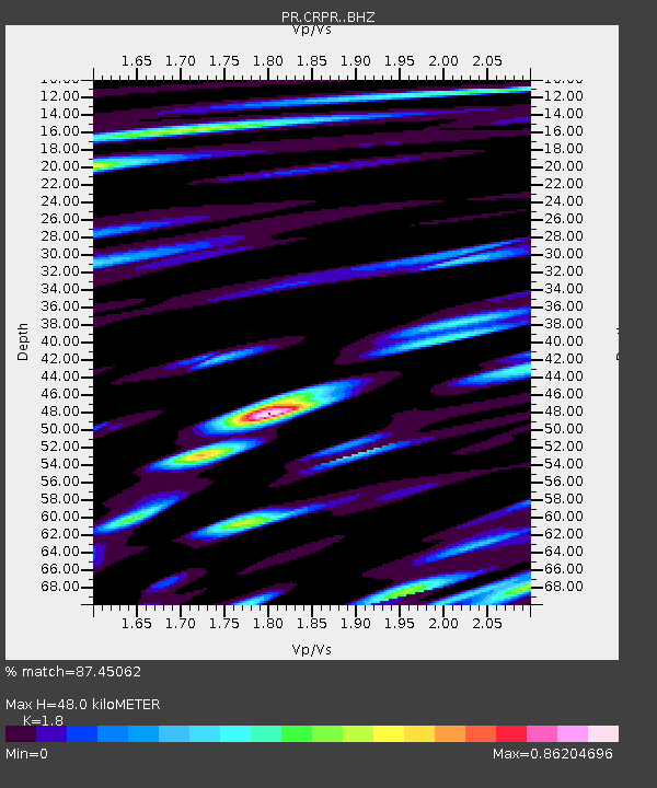
| Estimated Moho Depth: |
48.0 km |
| Estimated Crust Vp/Vs: |
1.80 |
| Assumed Crust Vp: |
5.14 km/s |
| Estimated Crust Vs: |
2.856 km/s |
| Estimated Crust Poisson's Ratio: |
0.28 |
|
| Radial Match: |
87.45062 % |
| Radial Bump: |
400 |
| Transverse Match: |
76.65808 % |
| Transverse Bump: |
400 |
| SOD ConfigId: |
11737051 |
| Insert Time: |
2019-04-26 19:00:48.053 +0000 |
| GWidth: |
2.5 |
| Max Bumps: |
400 |
| Tol: |
0.001 |
|

Signal To Noise
| Channel | StoN | STA | LTA |
| PR:CRPR: :BHZ:20170218T12:17:13.650Z | 12.166951 | 1.7427568E-6 | 1.4323695E-7 |
| PR:CRPR: :BHN:20170218T12:17:13.650Z | 3.913854 | 6.269842E-7 | 1.6019612E-7 |
| PR:CRPR: :BHE:20170218T12:17:13.650Z | 2.369819 | 3.5952516E-7 | 1.5170997E-7 |
| Arrivals |
| Ps | 7.8 SECOND |
| PpPs | 25 SECOND |
| PsPs/PpSs | 33 SECOND |


