You are here: Home > Network List > PR - Puerto Rico Seismic Network (PRSN) & Puerto Rico Strong Motion Program (PRSMP) Stations List
> Station MLPR Magueyes > Earthquake Result Viewer
MLPR Magueyes - Earthquake Result Viewer
| Earthquake location: |
Jujuy Province, Argentina |
| Earthquake latitude/longitude: |
-23.9/-66.7 |
| Earthquake time(UTC): |
2017/02/18 (049) 12:10:15 GMT |
| Earthquake Depth: |
201 km |
| Earthquake Magnitude: |
6.3 Mww |
| Earthquake Catalog/Contributor: |
NEIC PDE/us |
|
| Network: |
PR Puerto Rico Seismic Network (PRSN) & Puerto Rico Strong Motion Program (PRSMP) |
| Station: |
MLPR Magueyes |
| Lat/Lon: |
17.97 N/67.04 W |
| Elevation: |
0.0 m |
|
| Distance: |
41.6 deg |
| Az: |
359.49 deg |
| Baz: |
179.51 deg |
| Ray Param: |
0.07289796 |
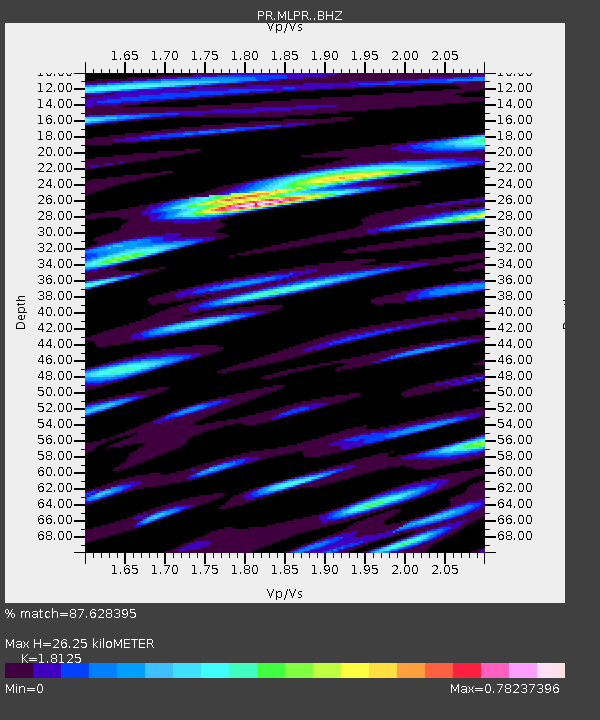
| Estimated Moho Depth: |
26.25 km |
| Estimated Crust Vp/Vs: |
1.81 |
| Assumed Crust Vp: |
4.082 km/s |
| Estimated Crust Vs: |
2.252 km/s |
| Estimated Crust Poisson's Ratio: |
0.28 |
|
| Radial Match: |
87.628395 % |
| Radial Bump: |
400 |
| Transverse Match: |
79.4548 % |
| Transverse Bump: |
400 |
| SOD ConfigId: |
11737051 |
| Insert Time: |
2019-04-26 19:00:51.628 +0000 |
| GWidth: |
2.5 |
| Max Bumps: |
400 |
| Tol: |
0.001 |
|

Signal To Noise
| Channel | StoN | STA | LTA |
| PR:MLPR: :BHZ:20170218T12:17:13.364996Z | 10.875256 | 1.455594E-6 | 1.3384458E-7 |
| PR:MLPR: :BHN:20170218T12:17:13.364996Z | 4.7371306 | 5.919882E-7 | 1.2496768E-7 |
| PR:MLPR: :BHE:20170218T12:17:13.364996Z | 2.2582126 | 3.2538208E-7 | 1.4408833E-7 |
| Arrivals |
| Ps | 5.4 SECOND |
| PpPs | 18 SECOND |
| PsPs/PpSs | 23 SECOND |


