You are here: Home > Network List > CI - Caltech Regional Seismic Network Stations List
> Station RPV Rancho Palos Verdes, California, USA > Earthquake Result Viewer
RPV Rancho Palos Verdes, California, USA - Earthquake Result Viewer
| Earthquake location: |
South Of Fiji Islands |
| Earthquake latitude/longitude: |
-25.8/179.5 |
| Earthquake time(UTC): |
2007/10/16 (289) 21:05:43 GMT |
| Earthquake Depth: |
509 km |
| Earthquake Magnitude: |
6.2 MB, 6.6 MW, 6.5 MW |
| Earthquake Catalog/Contributor: |
WHDF/NEIC |
|
| Network: |
CI Caltech Regional Seismic Network |
| Station: |
RPV Rancho Palos Verdes, California, USA |
| Lat/Lon: |
33.74 N/118.40 W |
| Elevation: |
64 m |
|
| Distance: |
83.5 deg |
| Az: |
47.808 deg |
| Baz: |
233.294 deg |
| Ray Param: |
0.044673212 |
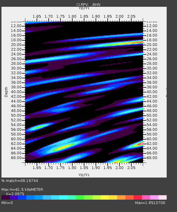
| Estimated Moho Depth: |
61.5 km |
| Estimated Crust Vp/Vs: |
2.10 |
| Assumed Crust Vp: |
6.048 km/s |
| Estimated Crust Vs: |
2.883 km/s |
| Estimated Crust Poisson's Ratio: |
0.35 |
|
| Radial Match: |
89.18744 % |
| Radial Bump: |
400 |
| Transverse Match: |
85.22885 % |
| Transverse Bump: |
400 |
| SOD ConfigId: |
2564 |
| Insert Time: |
2010-03-05 22:02:48.789 +0000 |
| GWidth: |
2.5 |
| Max Bumps: |
400 |
| Tol: |
0.001 |
|
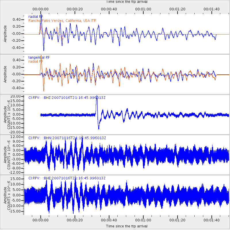
Signal To Noise
| Channel | StoN | STA | LTA |
| CI:RPV: :BHN:20071016T21:16:45.996013Z | 1.2961214 | 4.146314E-6 | 3.1990169E-6 |
| CI:RPV: :BHE:20071016T21:16:45.996013Z | 1.2433653 | 6.032655E-6 | 4.851877E-6 |
| CI:RPV: :BHZ:20071016T21:16:45.996013Z | 9.131726 | 8.524872E-6 | 9.335444E-7 |
| Arrivals |
| Ps | 11 SECOND |
| PpPs | 31 SECOND |
| PsPs/PpSs | 42 SECOND |


