You are here: Home > Network List > TA - USArray Transportable Network (new EarthScope stations) Stations List
> Station KMSC Kings Mountain, Blacksburg, SC, USA > Earthquake Result Viewer
KMSC Kings Mountain, Blacksburg, SC, USA - Earthquake Result Viewer
| Earthquake location: |
Jujuy Province, Argentina |
| Earthquake latitude/longitude: |
-23.9/-66.7 |
| Earthquake time(UTC): |
2017/02/18 (049) 12:10:15 GMT |
| Earthquake Depth: |
201 km |
| Earthquake Magnitude: |
6.3 Mww |
| Earthquake Catalog/Contributor: |
NEIC PDE/us |
|
| Network: |
TA USArray Transportable Network (new EarthScope stations) |
| Station: |
KMSC Kings Mountain, Blacksburg, SC, USA |
| Lat/Lon: |
35.14 N/81.33 W |
| Elevation: |
240 m |
|
| Distance: |
60.4 deg |
| Az: |
346.208 deg |
| Baz: |
164.562 deg |
| Ray Param: |
0.06093954 |
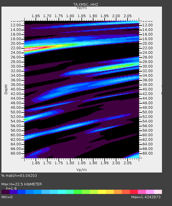
| Estimated Moho Depth: |
22.5 km |
| Estimated Crust Vp/Vs: |
1.60 |
| Assumed Crust Vp: |
6.419 km/s |
| Estimated Crust Vs: |
4.012 km/s |
| Estimated Crust Poisson's Ratio: |
0.18 |
|
| Radial Match: |
83.04203 % |
| Radial Bump: |
237 |
| Transverse Match: |
64.22236 % |
| Transverse Bump: |
383 |
| SOD ConfigId: |
11737051 |
| Insert Time: |
2019-04-26 19:01:28.213 +0000 |
| GWidth: |
2.5 |
| Max Bumps: |
400 |
| Tol: |
0.001 |
|

Signal To Noise
| Channel | StoN | STA | LTA |
| TA:KMSC: :HHZ:20170218T12:19:32.340002Z | 4.7856526 | 1.298235E-6 | 2.712765E-7 |
| TA:KMSC: :HHN:20170218T12:19:32.340002Z | 5.933883 | 7.8553614E-7 | 1.3238146E-7 |
| TA:KMSC: :HHE:20170218T12:19:32.340002Z | 1.8132577 | 3.888854E-7 | 2.144678E-7 |
| Arrivals |
| Ps | 2.2 SECOND |
| PpPs | 8.7 SECOND |
| PsPs/PpSs | 11 SECOND |


