You are here: Home > Network List > TA - USArray Transportable Network (new EarthScope stations) Stations List
> Station MDND Maddock, ND, USA > Earthquake Result Viewer
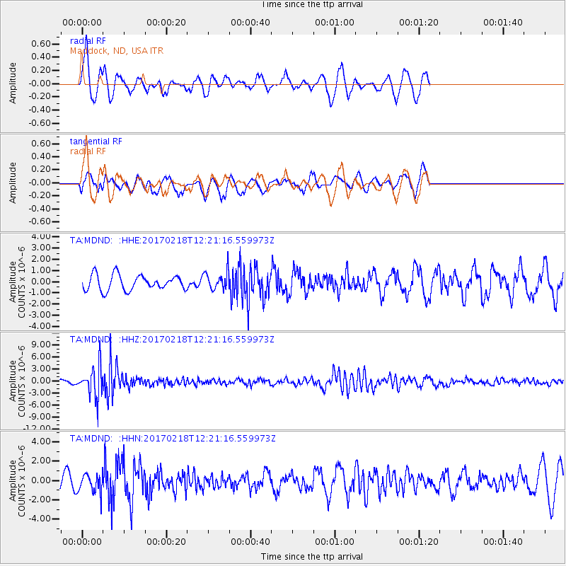
MDND Maddock, ND, USA - Earthquake Result Viewer
*The percent match for this event was below the threshold and hence no stack was calculated.
| Earthquake location: |
Jujuy Province, Argentina |
| Earthquake latitude/longitude: |
-23.9/-66.7 |
| Earthquake time(UTC): |
2017/02/18 (049) 12:10:15 GMT |
| Earthquake Depth: |
201 km |
| Earthquake Magnitude: |
6.3 Mww |
| Earthquake Catalog/Contributor: |
NEIC PDE/us |
|
| Network: |
TA USArray Transportable Network (new EarthScope stations) |
| Station: |
MDND Maddock, ND, USA |
| Lat/Lon: |
47.85 N/99.60 W |
| Elevation: |
479 m |
|
| Distance: |
77.3 deg |
| Az: |
337.966 deg |
| Baz: |
149.357 deg |
| Ray Param: |
$rayparam |
*The percent match for this event was below the threshold and hence was not used in the summary stack. |
|
| Radial Match: |
74.246124 % |
| Radial Bump: |
324 |
| Transverse Match: |
78.05738 % |
| Transverse Bump: |
378 |
| SOD ConfigId: |
11737051 |
| Insert Time: |
2019-04-26 19:01:31.439 +0000 |
| GWidth: |
2.5 |
| Max Bumps: |
400 |
| Tol: |
0.001 |
|
Signal To Noise
| Channel | StoN | STA | LTA |
| TA:MDND: :HHZ:20170218T12:21:16.559973Z | 8.151869 | 3.8642215E-6 | 4.7402887E-7 |
| TA:MDND: :HHN:20170218T12:21:16.559973Z | 0.86688006 | 9.575658E-7 | 1.1046117E-6 |
| TA:MDND: :HHE:20170218T12:21:16.559973Z | 1.1372406 | 7.754274E-7 | 6.818498E-7 |
| Arrivals |
| Ps | |
| PpPs | |
| PsPs/PpSs | |


