You are here: Home > Network List > CI - Caltech Regional Seismic Network Stations List
> Station RPV Rancho Palos Verdes, California, USA > Earthquake Result Viewer
RPV Rancho Palos Verdes, California, USA - Earthquake Result Viewer
| Earthquake location: |
Near West Coast Of Colombia |
| Earthquake latitude/longitude: |
3.0/-78.0 |
| Earthquake time(UTC): |
2007/09/10 (253) 01:49:14 GMT |
| Earthquake Depth: |
31 km |
| Earthquake Magnitude: |
6.1 MB, 6.7 MS, 6.8 MW |
| Earthquake Catalog/Contributor: |
WHDF/NEIC |
|
| Network: |
CI Caltech Regional Seismic Network |
| Station: |
RPV Rancho Palos Verdes, California, USA |
| Lat/Lon: |
33.74 N/118.40 W |
| Elevation: |
64 m |
|
| Distance: |
48.6 deg |
| Az: |
313.861 deg |
| Baz: |
120.213 deg |
| Ray Param: |
0.069225125 |
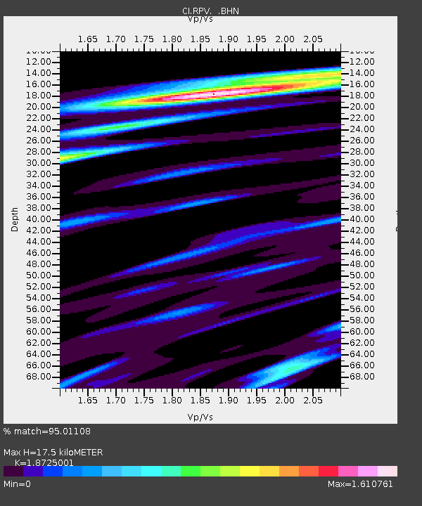
| Estimated Moho Depth: |
17.5 km |
| Estimated Crust Vp/Vs: |
1.87 |
| Assumed Crust Vp: |
6.048 km/s |
| Estimated Crust Vs: |
3.23 km/s |
| Estimated Crust Poisson's Ratio: |
0.30 |
|
| Radial Match: |
95.01108 % |
| Radial Bump: |
400 |
| Transverse Match: |
86.196976 % |
| Transverse Bump: |
400 |
| SOD ConfigId: |
2564 |
| Insert Time: |
2010-03-05 22:02:54.036 +0000 |
| GWidth: |
2.5 |
| Max Bumps: |
400 |
| Tol: |
0.001 |
|

Signal To Noise
| Channel | StoN | STA | LTA |
| CI:RPV: :BHN:20070910T01:57:23.872008Z | 1.28299 | 6.449246E-7 | 5.026731E-7 |
| CI:RPV: :BHE:20070910T01:57:23.872008Z | 1.9082594 | 8.0219206E-7 | 4.2037894E-7 |
| CI:RPV: :BHZ:20070910T01:57:23.872008Z | 4.833503 | 1.7528961E-6 | 3.6265547E-7 |
| Arrivals |
| Ps | 2.7 SECOND |
| PpPs | 7.9 SECOND |
| PsPs/PpSs | 11 SECOND |


