You are here: Home > Network List > TA - USArray Transportable Network (new EarthScope stations) Stations List
> Station Q24A Divide, CO, USA > Earthquake Result Viewer
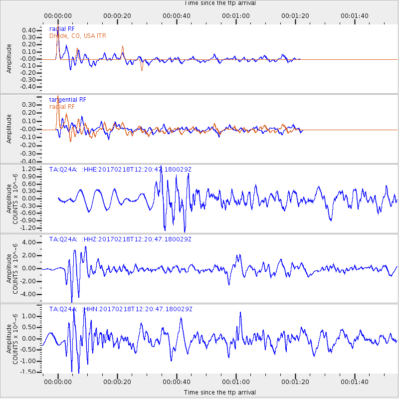
Q24A Divide, CO, USA - Earthquake Result Viewer
*The percent match for this event was below the threshold and hence no stack was calculated.
| Earthquake location: |
Jujuy Province, Argentina |
| Earthquake latitude/longitude: |
-23.9/-66.7 |
| Earthquake time(UTC): |
2017/02/18 (049) 12:10:15 GMT |
| Earthquake Depth: |
201 km |
| Earthquake Magnitude: |
6.3 Mww |
| Earthquake Catalog/Contributor: |
NEIC PDE/us |
|
| Network: |
TA USArray Transportable Network (new EarthScope stations) |
| Station: |
Q24A Divide, CO, USA |
| Lat/Lon: |
38.96 N/105.15 W |
| Elevation: |
2775 m |
|
| Distance: |
72.2 deg |
| Az: |
329.38 deg |
| Baz: |
143.281 deg |
| Ray Param: |
$rayparam |
*The percent match for this event was below the threshold and hence was not used in the summary stack. |
|
| Radial Match: |
71.388115 % |
| Radial Bump: |
323 |
| Transverse Match: |
57.347637 % |
| Transverse Bump: |
384 |
| SOD ConfigId: |
11737051 |
| Insert Time: |
2019-04-26 19:01:36.093 +0000 |
| GWidth: |
2.5 |
| Max Bumps: |
400 |
| Tol: |
0.001 |
|
Signal To Noise
| Channel | StoN | STA | LTA |
| TA:Q24A: :HHZ:20170218T12:20:47.180029Z | 8.096339 | 1.5746726E-6 | 1.9449193E-7 |
| TA:Q24A: :HHN:20170218T12:20:47.180029Z | 3.2959185 | 4.577971E-7 | 1.388982E-7 |
| TA:Q24A: :HHE:20170218T12:20:47.180029Z | 2.1154888 | 4.976102E-7 | 2.3522232E-7 |
| Arrivals |
| Ps | |
| PpPs | |
| PsPs/PpSs | |


