You are here: Home > Network List > TA - USArray Transportable Network (new EarthScope stations) Stations List
> Station SFIN Lafayette, IN, USA > Earthquake Result Viewer
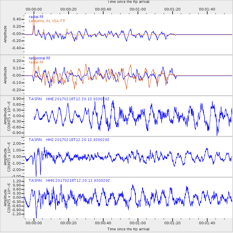
SFIN Lafayette, IN, USA - Earthquake Result Viewer
*The percent match for this event was below the threshold and hence no stack was calculated.
| Earthquake location: |
Jujuy Province, Argentina |
| Earthquake latitude/longitude: |
-23.9/-66.7 |
| Earthquake time(UTC): |
2017/02/18 (049) 12:10:15 GMT |
| Earthquake Depth: |
201 km |
| Earthquake Magnitude: |
6.3 Mww |
| Earthquake Catalog/Contributor: |
NEIC PDE/us |
|
| Network: |
TA USArray Transportable Network (new EarthScope stations) |
| Station: |
SFIN Lafayette, IN, USA |
| Lat/Lon: |
40.38 N/87.10 W |
| Elevation: |
165 m |
|
| Distance: |
66.7 deg |
| Az: |
343.144 deg |
| Baz: |
159.674 deg |
| Ray Param: |
$rayparam |
*The percent match for this event was below the threshold and hence was not used in the summary stack. |
|
| Radial Match: |
51.543804 % |
| Radial Bump: |
332 |
| Transverse Match: |
62.57754 % |
| Transverse Bump: |
345 |
| SOD ConfigId: |
11737051 |
| Insert Time: |
2019-04-26 19:01:38.571 +0000 |
| GWidth: |
2.5 |
| Max Bumps: |
400 |
| Tol: |
0.001 |
|
Signal To Noise
| Channel | StoN | STA | LTA |
| TA:SFIN: :HHZ:20170218T12:20:13.930029Z | 5.6921744 | 1.1394937E-6 | 2.0018602E-7 |
| TA:SFIN: :HHN:20170218T12:20:13.930029Z | 1.9771032 | 5.07232E-7 | 2.565531E-7 |
| TA:SFIN: :HHE:20170218T12:20:13.930029Z | 1.3263136 | 3.3315067E-7 | 2.5118544E-7 |
| Arrivals |
| Ps | |
| PpPs | |
| PsPs/PpSs | |


