You are here: Home > Network List > TA - USArray Transportable Network (new EarthScope stations) Stations List
> Station WHTX Lake Whitney, Meridian, TX, USA > Earthquake Result Viewer
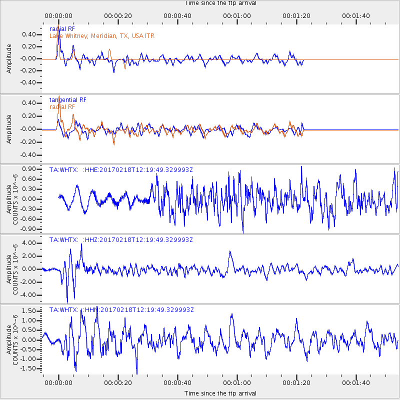
WHTX Lake Whitney, Meridian, TX, USA - Earthquake Result Viewer
*The percent match for this event was below the threshold and hence no stack was calculated.
| Earthquake location: |
Jujuy Province, Argentina |
| Earthquake latitude/longitude: |
-23.9/-66.7 |
| Earthquake time(UTC): |
2017/02/18 (049) 12:10:15 GMT |
| Earthquake Depth: |
201 km |
| Earthquake Magnitude: |
6.3 Mww |
| Earthquake Catalog/Contributor: |
NEIC PDE/us |
|
| Network: |
TA USArray Transportable Network (new EarthScope stations) |
| Station: |
WHTX Lake Whitney, Meridian, TX, USA |
| Lat/Lon: |
31.99 N/97.46 W |
| Elevation: |
190 m |
|
| Distance: |
62.9 deg |
| Az: |
330.771 deg |
| Baz: |
148.273 deg |
| Ray Param: |
$rayparam |
*The percent match for this event was below the threshold and hence was not used in the summary stack. |
|
| Radial Match: |
68.246574 % |
| Radial Bump: |
297 |
| Transverse Match: |
65.69943 % |
| Transverse Bump: |
396 |
| SOD ConfigId: |
11737051 |
| Insert Time: |
2019-04-26 19:01:42.935 +0000 |
| GWidth: |
2.5 |
| Max Bumps: |
400 |
| Tol: |
0.001 |
|
Signal To Noise
| Channel | StoN | STA | LTA |
| TA:WHTX: :HHZ:20170218T12:19:49.329993Z | 11.5077 | 1.6496017E-6 | 1.4334765E-7 |
| TA:WHTX: :HHN:20170218T12:19:49.329993Z | 2.7861633 | 5.040928E-7 | 1.8092722E-7 |
| TA:WHTX: :HHE:20170218T12:19:49.329993Z | 1.7025039 | 3.0533053E-7 | 1.7934205E-7 |
| Arrivals |
| Ps | |
| PpPs | |
| PsPs/PpSs | |


