You are here: Home > Network List > CI - Caltech Regional Seismic Network Stations List
> Station RPV Rancho Palos Verdes, California, USA > Earthquake Result Viewer
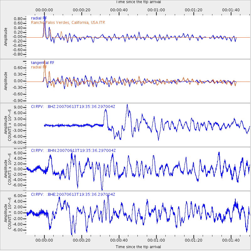
RPV Rancho Palos Verdes, California, USA - Earthquake Result Viewer

| Earthquake location: |
Near Coast Of Guatemala |
| Earthquake latitude/longitude: |
13.6/-90.6 |
| Earthquake time(UTC): |
2007/06/13 (164) 19:29:40 GMT |
| Earthquake Depth: |
23 km |
| Earthquake Magnitude: |
5.9 MB, 6.5 MS, 6.7 MW, 6.5 MW |
| Earthquake Catalog/Contributor: |
WHDF/NEIC |
|
| Network: |
CI Caltech Regional Seismic Network |
| Station: |
RPV Rancho Palos Verdes, California, USA |
| Lat/Lon: |
33.74 N/118.40 W |
| Elevation: |
64 m |
|
| Distance: |
32.3 deg |
| Az: |
313.298 deg |
| Baz: |
121.85 deg |
| Ray Param: |
0.078702 |
| Estimated Moho Depth: |
24.0 km |
| Estimated Crust Vp/Vs: |
1.67 |
| Assumed Crust Vp: |
6.048 km/s |
| Estimated Crust Vs: |
3.627 km/s |
| Estimated Crust Poisson's Ratio: |
0.22 |
|
| Radial Match: |
88.97888 % |
| Radial Bump: |
400 |
| Transverse Match: |
85.22228 % |
| Transverse Bump: |
400 |
| SOD ConfigId: |
2564 |
| Insert Time: |
2010-03-05 22:03:06.378 +0000 |
| GWidth: |
2.5 |
| Max Bumps: |
400 |
| Tol: |
0.001 |
|
Signal To Noise
| Channel | StoN | STA | LTA |
| CI:RPV: :BHN:20070613T19:35:36.297004Z | 5.434175 | 2.4757123E-6 | 4.5558198E-7 |
| CI:RPV: :BHE:20070613T19:35:36.297004Z | 5.1619587 | 2.3072764E-6 | 4.469769E-7 |
| CI:RPV: :BHZ:20070613T19:35:36.297004Z | 14.939699 | 3.8576286E-6 | 2.5821328E-7 |
| Arrivals |
| Ps | 2.9 SECOND |
| PpPs | 9.8 SECOND |
| PsPs/PpSs | 13 SECOND |


