You are here: Home > Network List > UW - Pacific Northwest Regional Seismic Network Stations List
> Station LEBA Lebam, WA, USA > Earthquake Result Viewer
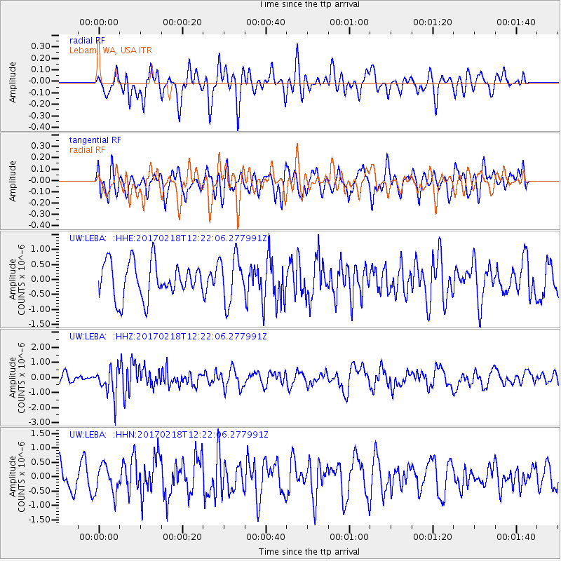
LEBA Lebam, WA, USA - Earthquake Result Viewer
*The percent match for this event was below the threshold and hence no stack was calculated.
| Earthquake location: |
Jujuy Province, Argentina |
| Earthquake latitude/longitude: |
-23.9/-66.7 |
| Earthquake time(UTC): |
2017/02/18 (049) 12:10:15 GMT |
| Earthquake Depth: |
201 km |
| Earthquake Magnitude: |
6.3 Mww |
| Earthquake Catalog/Contributor: |
NEIC PDE/us |
|
| Network: |
UW Pacific Northwest Regional Seismic Network |
| Station: |
LEBA Lebam, WA, USA |
| Lat/Lon: |
46.55 N/123.56 W |
| Elevation: |
73 m |
|
| Distance: |
86.9 deg |
| Az: |
324.63 deg |
| Baz: |
129.871 deg |
| Ray Param: |
$rayparam |
*The percent match for this event was below the threshold and hence was not used in the summary stack. |
|
| Radial Match: |
44.4279 % |
| Radial Bump: |
400 |
| Transverse Match: |
62.811142 % |
| Transverse Bump: |
400 |
| SOD ConfigId: |
11737051 |
| Insert Time: |
2019-04-26 19:02:34.340 +0000 |
| GWidth: |
2.5 |
| Max Bumps: |
400 |
| Tol: |
0.001 |
|
Signal To Noise
| Channel | StoN | STA | LTA |
| UW:LEBA: :HHZ:20170218T12:22:06.277991Z | 2.9423637 | 9.316192E-7 | 3.166227E-7 |
| UW:LEBA: :HHN:20170218T12:22:06.277991Z | 1.0241529 | 4.862921E-7 | 4.7482374E-7 |
| UW:LEBA: :HHE:20170218T12:22:06.277991Z | 1.2978214 | 7.6356724E-7 | 5.8834536E-7 |
| Arrivals |
| Ps | |
| PpPs | |
| PsPs/PpSs | |


