You are here: Home > Network List > UW - Pacific Northwest Regional Seismic Network Stations List
> Station MRBL Marblemount, WA, USA > Earthquake Result Viewer
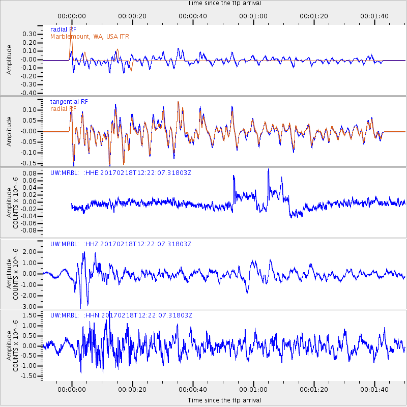
MRBL Marblemount, WA, USA - Earthquake Result Viewer
*The percent match for this event was below the threshold and hence no stack was calculated.
| Earthquake location: |
Jujuy Province, Argentina |
| Earthquake latitude/longitude: |
-23.9/-66.7 |
| Earthquake time(UTC): |
2017/02/18 (049) 12:10:15 GMT |
| Earthquake Depth: |
201 km |
| Earthquake Magnitude: |
6.3 Mww |
| Earthquake Catalog/Contributor: |
NEIC PDE/us |
|
| Network: |
UW Pacific Northwest Regional Seismic Network |
| Station: |
MRBL Marblemount, WA, USA |
| Lat/Lon: |
48.52 N/121.48 W |
| Elevation: |
75 m |
|
| Distance: |
87.2 deg |
| Az: |
327.048 deg |
| Baz: |
131.525 deg |
| Ray Param: |
$rayparam |
*The percent match for this event was below the threshold and hence was not used in the summary stack. |
|
| Radial Match: |
72.48118 % |
| Radial Bump: |
400 |
| Transverse Match: |
72.51635 % |
| Transverse Bump: |
400 |
| SOD ConfigId: |
11737051 |
| Insert Time: |
2019-04-26 19:02:36.910 +0000 |
| GWidth: |
2.5 |
| Max Bumps: |
400 |
| Tol: |
0.001 |
|
Signal To Noise
| Channel | StoN | STA | LTA |
| UW:MRBL: :HHZ:20170218T12:22:07.31803Z | 6.5820446 | 1.0773286E-6 | 1.636769E-7 |
| UW:MRBL: :HHN:20170218T12:22:07.31803Z | 3.4273608 | 4.1721813E-7 | 1.217316E-7 |
| UW:MRBL: :HHE:20170218T12:22:07.31803Z | 1.0120339 | 8.580019E-9 | 8.477995E-9 |
| Arrivals |
| Ps | |
| PpPs | |
| PsPs/PpSs | |


