You are here: Home > Network List > UW - Pacific Northwest Regional Seismic Network Stations List
> Station YACT Amboy, WA, USA > Earthquake Result Viewer
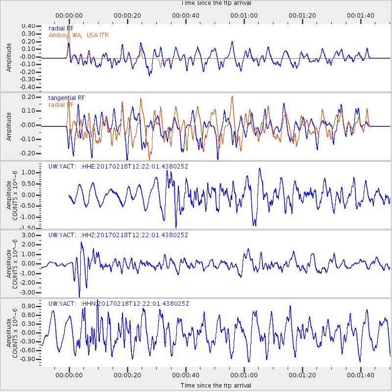
YACT Amboy, WA, USA - Earthquake Result Viewer
*The percent match for this event was below the threshold and hence no stack was calculated.
| Earthquake location: |
Jujuy Province, Argentina |
| Earthquake latitude/longitude: |
-23.9/-66.7 |
| Earthquake time(UTC): |
2017/02/18 (049) 12:10:15 GMT |
| Earthquake Depth: |
201 km |
| Earthquake Magnitude: |
6.3 Mww |
| Earthquake Catalog/Contributor: |
NEIC PDE/us |
|
| Network: |
UW Pacific Northwest Regional Seismic Network |
| Station: |
YACT Amboy, WA, USA |
| Lat/Lon: |
45.93 N/122.42 W |
| Elevation: |
211 m |
|
| Distance: |
85.9 deg |
| Az: |
324.675 deg |
| Baz: |
130.698 deg |
| Ray Param: |
$rayparam |
*The percent match for this event was below the threshold and hence was not used in the summary stack. |
|
| Radial Match: |
64.10777 % |
| Radial Bump: |
400 |
| Transverse Match: |
54.40475 % |
| Transverse Bump: |
392 |
| SOD ConfigId: |
11737051 |
| Insert Time: |
2019-04-26 19:03:03.650 +0000 |
| GWidth: |
2.5 |
| Max Bumps: |
400 |
| Tol: |
0.001 |
|
Signal To Noise
| Channel | StoN | STA | LTA |
| UW:YACT: :HHZ:20170218T12:22:01.438025Z | 4.553584 | 1.2843126E-6 | 2.8204437E-7 |
| UW:YACT: :HHN:20170218T12:22:01.438025Z | 1.306559 | 4.7553135E-7 | 3.6395707E-7 |
| UW:YACT: :HHE:20170218T12:22:01.438025Z | 2.434696 | 7.0821596E-7 | 2.9088477E-7 |
| Arrivals |
| Ps | |
| PpPs | |
| PsPs/PpSs | |


