You are here: Home > Network List > CI - Caltech Regional Seismic Network Stations List
> Station RPV Rancho Palos Verdes, California, USA > Earthquake Result Viewer
RPV Rancho Palos Verdes, California, USA - Earthquake Result Viewer
| Earthquake location: |
Tonga Islands |
| Earthquake latitude/longitude: |
-15.2/-175.6 |
| Earthquake time(UTC): |
1997/08/29 (241) 06:54:00 GMT |
| Earthquake Depth: |
33 km |
| Earthquake Magnitude: |
5.6 MB, 6.4 MS, 6.5 UNKNOWN, 6.4 MW |
| Earthquake Catalog/Contributor: |
WHDF/NEIC |
|
| Network: |
CI Caltech Regional Seismic Network |
| Station: |
RPV Rancho Palos Verdes, California, USA |
| Lat/Lon: |
33.74 N/118.40 W |
| Elevation: |
64 m |
|
| Distance: |
73.0 deg |
| Az: |
47.055 deg |
| Baz: |
237.996 deg |
| Ray Param: |
0.05321638 |
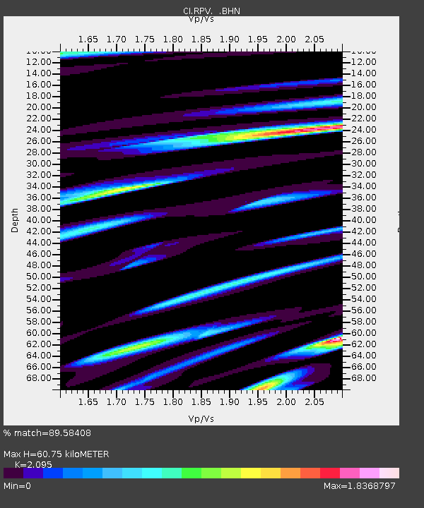
| Estimated Moho Depth: |
60.75 km |
| Estimated Crust Vp/Vs: |
2.10 |
| Assumed Crust Vp: |
6.048 km/s |
| Estimated Crust Vs: |
2.887 km/s |
| Estimated Crust Poisson's Ratio: |
0.35 |
|
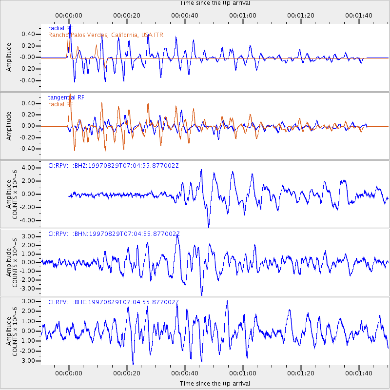
| Radial Match: |
89.58408 % |
| Radial Bump: |
400 |
| Transverse Match: |
68.967865 % |
| Transverse Bump: |
400 |
| SOD ConfigId: |
4770 |
| Insert Time: |
2010-03-05 22:03:43.859 +0000 |
| GWidth: |
2.5 |
| Max Bumps: |
400 |
| Tol: |
0.001 |
|
Signal To Noise
| Channel | StoN | STA | LTA |
| CI:RPV: :BHN:19970829T07:04:55.877002Z | 0.75698376 | 2.5050895E-7 | 3.3093042E-7 |
| CI:RPV: :BHE:19970829T07:04:55.877002Z | 1.038844 | 4.369678E-7 | 4.2062888E-7 |
| CI:RPV: :BHZ:19970829T07:04:55.877002Z | 1.4596571 | 2.4464302E-7 | 1.6760308E-7 |
| Arrivals |
| Ps | 11 SECOND |
| PpPs | 30 SECOND |
| PsPs/PpSs | 42 SECOND |


