You are here: Home > Network List > CI - Caltech Regional Seismic Network Stations List
> Station RPV Rancho Palos Verdes, California, USA > Earthquake Result Viewer
RPV Rancho Palos Verdes, California, USA - Earthquake Result Viewer
| Earthquake location: |
Near Coast Of Ecuador |
| Earthquake latitude/longitude: |
-0.6/-80.4 |
| Earthquake time(UTC): |
1998/08/04 (216) 18:59:20 GMT |
| Earthquake Depth: |
33 km |
| Earthquake Magnitude: |
6.2 MB, 7.1 MS, 7.1 UNKNOWN, 7.0 ME |
| Earthquake Catalog/Contributor: |
WHDF/NEIC |
|
| Network: |
CI Caltech Regional Seismic Network |
| Station: |
RPV Rancho Palos Verdes, California, USA |
| Lat/Lon: |
33.74 N/118.40 W |
| Elevation: |
64 m |
|
| Distance: |
49.4 deg |
| Az: |
317.481 deg |
| Baz: |
125.803 deg |
| Ray Param: |
0.068663 |
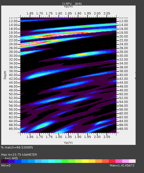
| Estimated Moho Depth: |
23.75 km |
| Estimated Crust Vp/Vs: |
1.64 |
| Assumed Crust Vp: |
6.048 km/s |
| Estimated Crust Vs: |
3.677 km/s |
| Estimated Crust Poisson's Ratio: |
0.21 |
|
| Radial Match: |
96.538895 % |
| Radial Bump: |
400 |
| Transverse Match: |
85.436195 % |
| Transverse Bump: |
400 |
| SOD ConfigId: |
3770 |
| Insert Time: |
2010-03-05 22:04:06.511 +0000 |
| GWidth: |
2.5 |
| Max Bumps: |
400 |
| Tol: |
0.001 |
|

Signal To Noise
| Channel | StoN | STA | LTA |
| CI:RPV: :BHN:19980804T19:07:36.036005Z | 0.8725156 | 4.8323017E-7 | 5.5383555E-7 |
| CI:RPV: :BHE:19980804T19:07:36.036005Z | 1.7346956 | 9.163462E-7 | 5.282461E-7 |
| CI:RPV: :BHZ:19980804T19:07:36.036005Z | 1.2673103 | 6.177606E-7 | 4.87458E-7 |
| Arrivals |
| Ps | 2.7 SECOND |
| PpPs | 9.8 SECOND |
| PsPs/PpSs | 13 SECOND |


