You are here: Home > Network List > CI - Caltech Regional Seismic Network Stations List
> Station RPV Rancho Palos Verdes, California, USA > Earthquake Result Viewer
RPV Rancho Palos Verdes, California, USA - Earthquake Result Viewer
| Earthquake location: |
Peru-Brazil Border Region |
| Earthquake latitude/longitude: |
-8.1/-74.2 |
| Earthquake time(UTC): |
1998/04/03 (093) 22:01:48 GMT |
| Earthquake Depth: |
165 km |
| Earthquake Magnitude: |
6.1 MB, 5.6 MS, 6.6 UNKNOWN, 6.6 MW |
| Earthquake Catalog/Contributor: |
WHDF/NEIC |
|
| Network: |
CI Caltech Regional Seismic Network |
| Station: |
RPV Rancho Palos Verdes, California, USA |
| Lat/Lon: |
33.74 N/118.40 W |
| Elevation: |
64 m |
|
| Distance: |
59.1 deg |
| Az: |
317.408 deg |
| Baz: |
126.476 deg |
| Ray Param: |
0.061905038 |
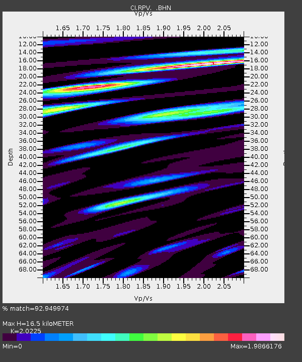
| Estimated Moho Depth: |
16.5 km |
| Estimated Crust Vp/Vs: |
2.02 |
| Assumed Crust Vp: |
6.048 km/s |
| Estimated Crust Vs: |
2.99 km/s |
| Estimated Crust Poisson's Ratio: |
0.34 |
|
| Radial Match: |
92.949974 % |
| Radial Bump: |
400 |
| Transverse Match: |
86.53079 % |
| Transverse Bump: |
400 |
| SOD ConfigId: |
3770 |
| Insert Time: |
2010-03-05 22:04:08.350 +0000 |
| GWidth: |
2.5 |
| Max Bumps: |
400 |
| Tol: |
0.001 |
|
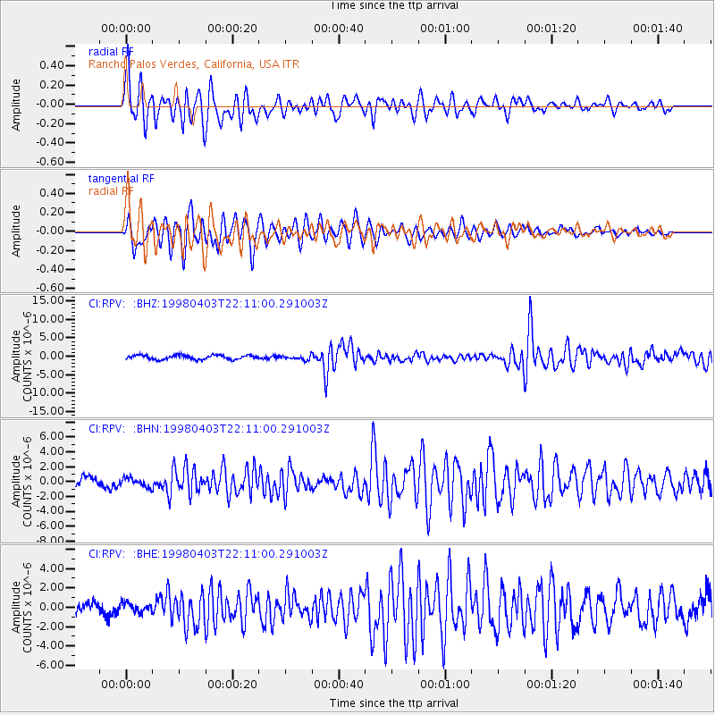
Signal To Noise
| Channel | StoN | STA | LTA |
| CI:RPV: :BHN:19980403T22:11:00.291003Z | 0.9205425 | 6.224979E-7 | 6.7622943E-7 |
| CI:RPV: :BHE:19980403T22:11:00.291003Z | 0.7179111 | 4.8247E-7 | 6.7204695E-7 |
| CI:RPV: :BHZ:19980403T22:11:00.291003Z | 1.0664607 | 6.0397645E-7 | 5.6633723E-7 |
| Arrivals |
| Ps | 2.9 SECOND |
| PpPs | 8.0 SECOND |
| PsPs/PpSs | 11 SECOND |


