You are here: Home > Network List > TA - USArray Transportable Network (new EarthScope stations) Stations List
> Station A36M Sachs Harbour, NT, CAN > Earthquake Result Viewer
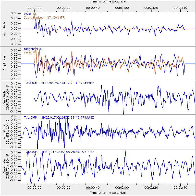
A36M Sachs Harbour, NT, CAN - Earthquake Result Viewer
*The percent match for this event was below the threshold and hence no stack was calculated.
| Earthquake location: |
Near East Coast Of Honshu, Japan |
| Earthquake latitude/longitude: |
35.6/140.8 |
| Earthquake time(UTC): |
2017/02/19 (050) 09:19:30 GMT |
| Earthquake Depth: |
39 km |
| Earthquake Magnitude: |
5.5 mb |
| Earthquake Catalog/Contributor: |
NEIC PDE/us |
|
| Network: |
TA USArray Transportable Network (new EarthScope stations) |
| Station: |
A36M Sachs Harbour, NT, CAN |
| Lat/Lon: |
71.99 N/125.25 W |
| Elevation: |
32 m |
|
| Distance: |
57.7 deg |
| Az: |
21.533 deg |
| Baz: |
286.046 deg |
| Ray Param: |
$rayparam |
*The percent match for this event was below the threshold and hence was not used in the summary stack. |
|
| Radial Match: |
59.241962 % |
| Radial Bump: |
400 |
| Transverse Match: |
68.54493 % |
| Transverse Bump: |
400 |
| SOD ConfigId: |
11737051 |
| Insert Time: |
2019-04-26 19:12:14.622 +0000 |
| GWidth: |
2.5 |
| Max Bumps: |
400 |
| Tol: |
0.001 |
|
Signal To Noise
| Channel | StoN | STA | LTA |
| TA:A36M: :BHZ:20170219T09:28:46.974998Z | 2.3592443 | 2.8887206E-7 | 1.2244263E-7 |
| TA:A36M: :BHN:20170219T09:28:46.974998Z | 2.1126747 | 2.8439615E-7 | 1.3461427E-7 |
| TA:A36M: :BHE:20170219T09:28:46.974998Z | 0.71036017 | 8.1563186E-8 | 1.14819485E-7 |
| Arrivals |
| Ps | |
| PpPs | |
| PsPs/PpSs | |


