You are here: Home > Network List > CI - Caltech Regional Seismic Network Stations List
> Station RPV Rancho Palos Verdes, California, USA > Earthquake Result Viewer
RPV Rancho Palos Verdes, California, USA - Earthquake Result Viewer

| Earthquake location: |
Southeast Of Loyalty Islands |
| Earthquake latitude/longitude: |
-22.3/170.9 |
| Earthquake time(UTC): |
1998/01/04 (004) 06:11:58 GMT |
| Earthquake Depth: |
101 km |
| Earthquake Magnitude: |
6.4 MB, 7.4 UNKNOWN, 7.3 ME |
| Earthquake Catalog/Contributor: |
WHDF/NEIC |
|
| Network: |
CI Caltech Regional Seismic Network |
| Station: |
RPV Rancho Palos Verdes, California, USA |
| Lat/Lon: |
33.74 N/118.40 W |
| Elevation: |
64 m |
|
| Distance: |
87.3 deg |
| Az: |
51.925 deg |
| Baz: |
241.035 deg |
| Ray Param: |
0.04319828 |
| Estimated Moho Depth: |
61.75 km |
| Estimated Crust Vp/Vs: |
2.10 |
| Assumed Crust Vp: |
6.048 km/s |
| Estimated Crust Vs: |
2.883 km/s |
| Estimated Crust Poisson's Ratio: |
0.35 |
|
| Radial Match: |
87.814316 % |
| Radial Bump: |
400 |
| Transverse Match: |
80.915726 % |
| Transverse Bump: |
400 |
| SOD ConfigId: |
4770 |
| Insert Time: |
2010-03-05 22:04:19.960 +0000 |
| GWidth: |
2.5 |
| Max Bumps: |
400 |
| Tol: |
0.001 |
|
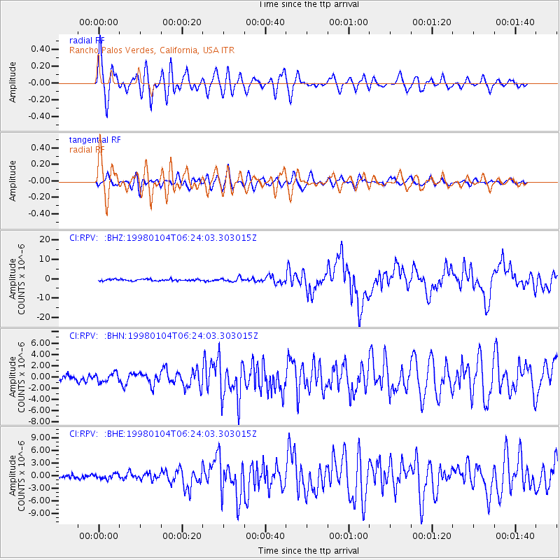
Signal To Noise
| Channel | StoN | STA | LTA |
| CI:RPV: :BHN:19980104T06:24:03.303015Z | 1.3263568 | 8.1309406E-7 | 6.130282E-7 |
| CI:RPV: :BHE:19980104T06:24:03.303015Z | 1.2327356 | 6.169043E-7 | 5.004352E-7 |
| CI:RPV: :BHZ:19980104T06:24:03.303015Z | 2.4717147 | 1.0415093E-6 | 4.213712E-7 |
| Arrivals |
| Ps | 11 SECOND |
| PpPs | 31 SECOND |
| PsPs/PpSs | 42 SECOND |


