You are here: Home > Network List > CI - Caltech Regional Seismic Network Stations List
> Station GRA Grapevine Ranger Station, Death Valley, CA, USA > Earthquake Result Viewer
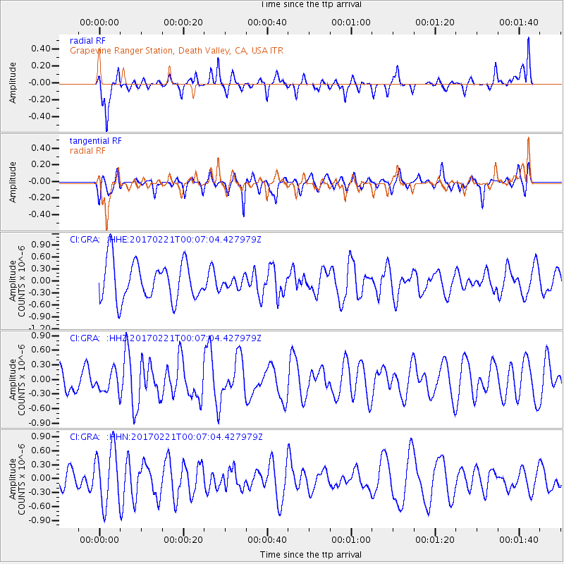
GRA Grapevine Ranger Station, Death Valley, CA, USA - Earthquake Result Viewer
*The percent match for this event was below the threshold and hence no stack was calculated.
| Earthquake location: |
Fiji Islands Region |
| Earthquake latitude/longitude: |
-15.0/-176.4 |
| Earthquake time(UTC): |
2017/02/20 (051) 23:55:48 GMT |
| Earthquake Depth: |
6.0 km |
| Earthquake Magnitude: |
5.5 Mww |
| Earthquake Catalog/Contributor: |
NEIC PDE/us |
|
| Network: |
CI Caltech Regional Seismic Network |
| Station: |
GRA Grapevine Ranger Station, Death Valley, CA, USA |
| Lat/Lon: |
37.00 N/117.37 W |
| Elevation: |
689 m |
|
| Distance: |
75.8 deg |
| Az: |
45.06 deg |
| Baz: |
238.702 deg |
| Ray Param: |
$rayparam |
*The percent match for this event was below the threshold and hence was not used in the summary stack. |
|
| Radial Match: |
61.44887 % |
| Radial Bump: |
400 |
| Transverse Match: |
47.76056 % |
| Transverse Bump: |
361 |
| SOD ConfigId: |
11737051 |
| Insert Time: |
2019-04-26 19:17:29.700 +0000 |
| GWidth: |
2.5 |
| Max Bumps: |
400 |
| Tol: |
0.001 |
|
Signal To Noise
| Channel | StoN | STA | LTA |
| CI:GRA: :HHZ:20170221T00:07:04.427979Z | 1.063059 | 2.1475947E-7 | 2.0202027E-7 |
| CI:GRA: :HHN:20170221T00:07:04.427979Z | 2.2433596 | 6.134573E-7 | 2.7345473E-7 |
| CI:GRA: :HHE:20170221T00:07:04.427979Z | 0.27612567 | 1.334462E-7 | 4.8328076E-7 |
| Arrivals |
| Ps | |
| PpPs | |
| PsPs/PpSs | |


