You are here: Home > Network List > CI - Caltech Regional Seismic Network Stations List
> Station RPV Rancho Palos Verdes, California, USA > Earthquake Result Viewer
RPV Rancho Palos Verdes, California, USA - Earthquake Result Viewer
| Earthquake location: |
Ecuador |
| Earthquake latitude/longitude: |
-1.3/-77.5 |
| Earthquake time(UTC): |
1999/08/28 (240) 12:40:06 GMT |
| Earthquake Depth: |
196 km |
| Earthquake Magnitude: |
5.9 MB, 6.3 MW, 6.2 MW |
| Earthquake Catalog/Contributor: |
WHDF/NEIC |
|
| Network: |
CI Caltech Regional Seismic Network |
| Station: |
RPV Rancho Palos Verdes, California, USA |
| Lat/Lon: |
33.74 N/118.40 W |
| Elevation: |
64 m |
|
| Distance: |
51.8 deg |
| Az: |
316.12 deg |
| Baz: |
123.731 deg |
| Ray Param: |
0.06644726 |
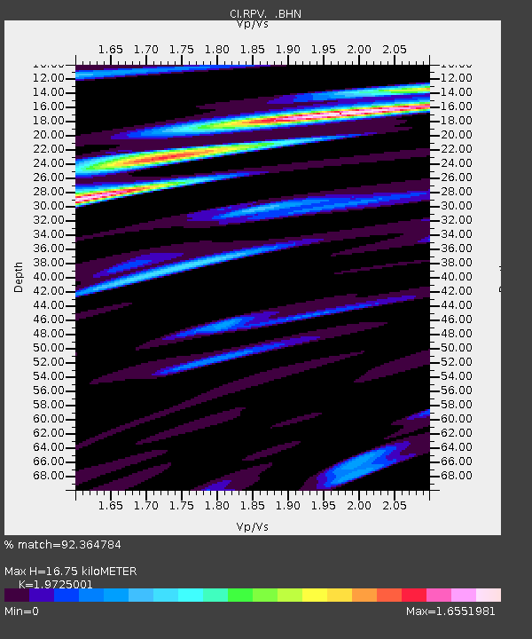
| Estimated Moho Depth: |
16.75 km |
| Estimated Crust Vp/Vs: |
1.97 |
| Assumed Crust Vp: |
6.048 km/s |
| Estimated Crust Vs: |
3.066 km/s |
| Estimated Crust Poisson's Ratio: |
0.33 |
|
| Radial Match: |
92.364784 % |
| Radial Bump: |
400 |
| Transverse Match: |
76.68116 % |
| Transverse Bump: |
400 |
| SOD ConfigId: |
3787 |
| Insert Time: |
2010-03-05 22:04:46.637 +0000 |
| GWidth: |
2.5 |
| Max Bumps: |
400 |
| Tol: |
0.001 |
|

Signal To Noise
| Channel | StoN | STA | LTA |
| CI:RPV: :BHN:19990828T12:48:23.553007Z | 4.874367 | 1.7740437E-6 | 3.639536E-7 |
| CI:RPV: :BHE:19990828T12:48:23.553007Z | 4.774708 | 2.0136245E-6 | 4.2172724E-7 |
| CI:RPV: :BHZ:19990828T12:48:23.553007Z | 19.288261 | 4.8984493E-6 | 2.539601E-7 |
| Arrivals |
| Ps | 2.8 SECOND |
| PpPs | 7.9 SECOND |
| PsPs/PpSs | 11 SECOND |


