You are here: Home > Network List > CI - Caltech Regional Seismic Network Stations List
> Station RPV Rancho Palos Verdes, California, USA > Earthquake Result Viewer
RPV Rancho Palos Verdes, California, USA - Earthquake Result Viewer
| Earthquake location: |
Kermadec Islands Region |
| Earthquake latitude/longitude: |
-28.6/-177.6 |
| Earthquake time(UTC): |
1999/07/19 (200) 02:17:03 GMT |
| Earthquake Depth: |
39 km |
| Earthquake Magnitude: |
6.3 MB, 6.2 MS, 6.4 MW, 6.3 ME |
| Earthquake Catalog/Contributor: |
WHDF/NEIC |
|
| Network: |
CI Caltech Regional Seismic Network |
| Station: |
RPV Rancho Palos Verdes, California, USA |
| Lat/Lon: |
33.74 N/118.40 W |
| Elevation: |
64 m |
|
| Distance: |
83.6 deg |
| Az: |
46.075 deg |
| Baz: |
229.453 deg |
| Ray Param: |
0.04601515 |
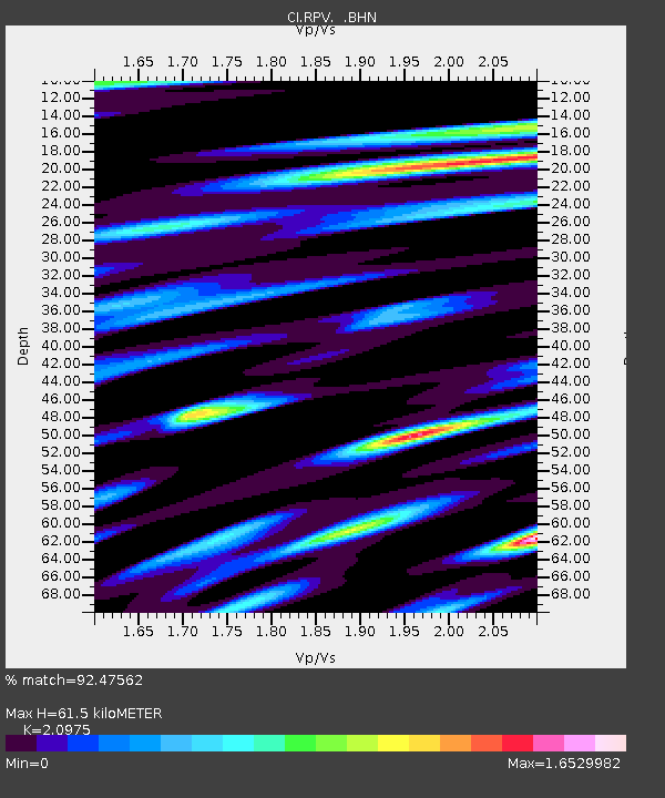
| Estimated Moho Depth: |
61.5 km |
| Estimated Crust Vp/Vs: |
2.10 |
| Assumed Crust Vp: |
6.048 km/s |
| Estimated Crust Vs: |
2.883 km/s |
| Estimated Crust Poisson's Ratio: |
0.35 |
|
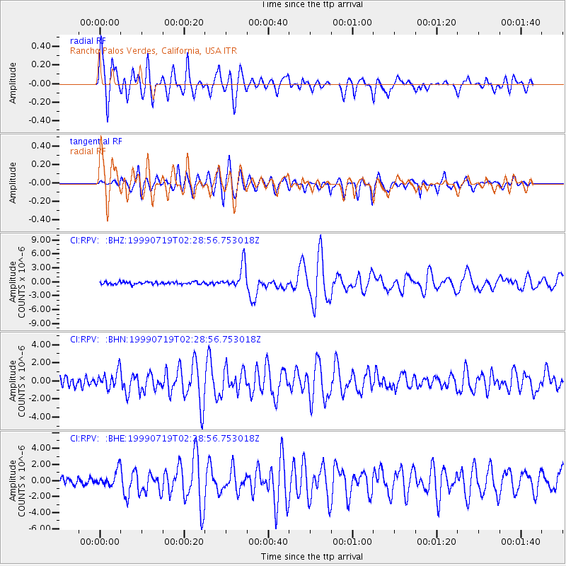
| Radial Match: |
92.47562 % |
| Radial Bump: |
400 |
| Transverse Match: |
84.95665 % |
| Transverse Bump: |
400 |
| SOD ConfigId: |
3787 |
| Insert Time: |
2010-03-05 22:04:58.130 +0000 |
| GWidth: |
2.5 |
| Max Bumps: |
400 |
| Tol: |
0.001 |
|
Signal To Noise
| Channel | StoN | STA | LTA |
| CI:RPV: :BHN:19990719T02:28:56.753018Z | 2.4578524 | 9.5224266E-7 | 3.8742874E-7 |
| CI:RPV: :BHE:19990719T02:28:56.753018Z | 2.451718 | 1.033302E-6 | 4.2146044E-7 |
| CI:RPV: :BHZ:19990719T02:28:56.753018Z | 10.219386 | 2.6668572E-6 | 2.609606E-7 |
| Arrivals |
| Ps | 11 SECOND |
| PpPs | 31 SECOND |
| PsPs/PpSs | 42 SECOND |


