You are here: Home > Network List > TA - USArray Transportable Network (new EarthScope stations) Stations List
> Station A21K Barrow, AK, USA > Earthquake Result Viewer
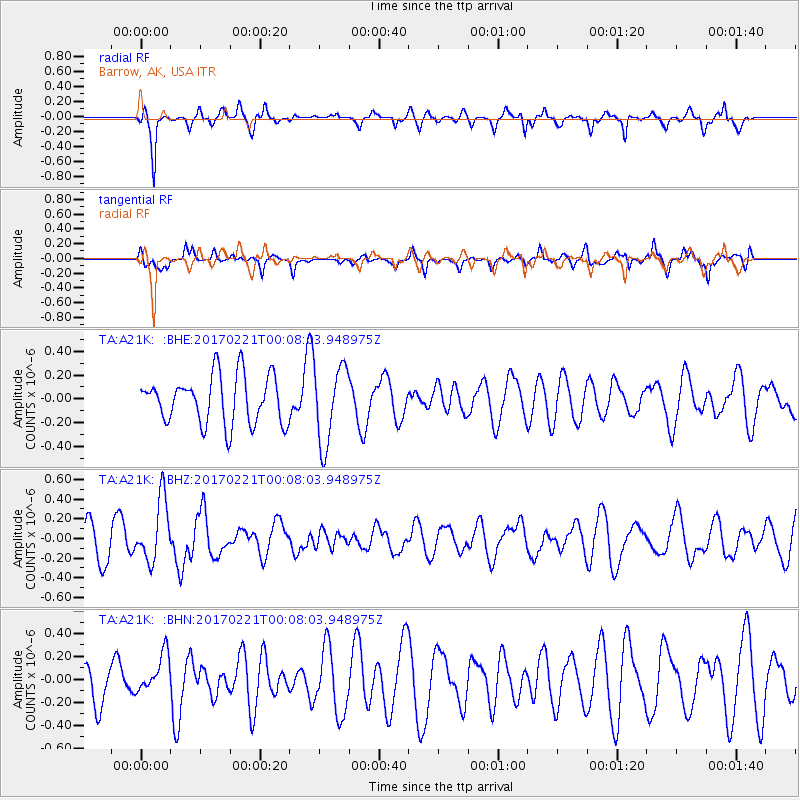
A21K Barrow, AK, USA - Earthquake Result Viewer
*The percent match for this event was below the threshold and hence no stack was calculated.
| Earthquake location: |
Fiji Islands Region |
| Earthquake latitude/longitude: |
-15.0/-176.4 |
| Earthquake time(UTC): |
2017/02/20 (051) 23:55:48 GMT |
| Earthquake Depth: |
6.0 km |
| Earthquake Magnitude: |
5.5 Mww |
| Earthquake Catalog/Contributor: |
NEIC PDE/us |
|
| Network: |
TA USArray Transportable Network (new EarthScope stations) |
| Station: |
A21K Barrow, AK, USA |
| Lat/Lon: |
71.32 N/156.62 W |
| Elevation: |
577 m |
|
| Distance: |
87.1 deg |
| Az: |
6.262 deg |
| Baz: |
199.099 deg |
| Ray Param: |
$rayparam |
*The percent match for this event was below the threshold and hence was not used in the summary stack. |
|
| Radial Match: |
74.17163 % |
| Radial Bump: |
341 |
| Transverse Match: |
54.223022 % |
| Transverse Bump: |
363 |
| SOD ConfigId: |
11737051 |
| Insert Time: |
2019-04-26 19:20:55.718 +0000 |
| GWidth: |
2.5 |
| Max Bumps: |
400 |
| Tol: |
0.001 |
|
Signal To Noise
| Channel | StoN | STA | LTA |
| TA:A21K: :BHZ:20170221T00:08:03.948975Z | 1.9106959 | 3.1781465E-7 | 1.6633452E-7 |
| TA:A21K: :BHN:20170221T00:08:03.948975Z | 1.081857 | 1.7069482E-7 | 1.5777948E-7 |
| TA:A21K: :BHE:20170221T00:08:03.948975Z | 1.6308984 | 3.2987293E-7 | 2.0226456E-7 |
| Arrivals |
| Ps | |
| PpPs | |
| PsPs/PpSs | |


