You are here: Home > Network List > TA - USArray Transportable Network (new EarthScope stations) Stations List
> Station G22K Bettles, AK, USA > Earthquake Result Viewer
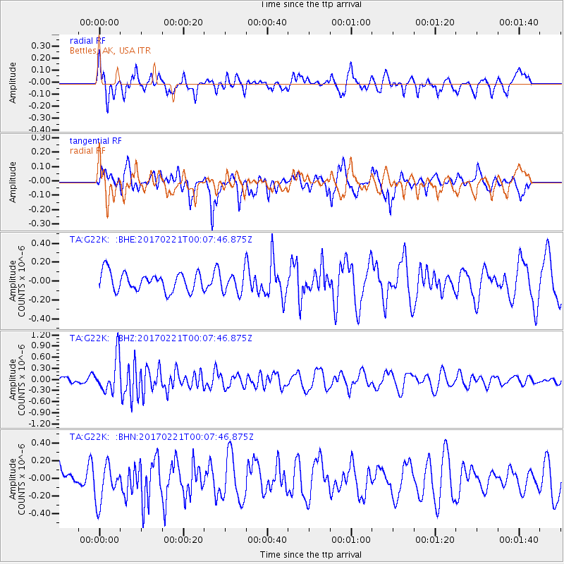
G22K Bettles, AK, USA - Earthquake Result Viewer
*The percent match for this event was below the threshold and hence no stack was calculated.
| Earthquake location: |
Fiji Islands Region |
| Earthquake latitude/longitude: |
-15.0/-176.4 |
| Earthquake time(UTC): |
2017/02/20 (051) 23:55:48 GMT |
| Earthquake Depth: |
6.0 km |
| Earthquake Magnitude: |
5.5 Mww |
| Earthquake Catalog/Contributor: |
NEIC PDE/us |
|
| Network: |
TA USArray Transportable Network (new EarthScope stations) |
| Station: |
G22K Bettles, AK, USA |
| Lat/Lon: |
66.92 N/151.51 W |
| Elevation: |
205 m |
|
| Distance: |
83.7 deg |
| Az: |
9.603 deg |
| Baz: |
204.141 deg |
| Ray Param: |
$rayparam |
*The percent match for this event was below the threshold and hence was not used in the summary stack. |
|
| Radial Match: |
54.819473 % |
| Radial Bump: |
396 |
| Transverse Match: |
65.8502 % |
| Transverse Bump: |
370 |
| SOD ConfigId: |
11737051 |
| Insert Time: |
2019-04-26 19:21:03.651 +0000 |
| GWidth: |
2.5 |
| Max Bumps: |
400 |
| Tol: |
0.001 |
|
Signal To Noise
| Channel | StoN | STA | LTA |
| TA:G22K: :BHZ:20170221T00:07:46.875Z | 3.4982169 | 4.83042E-7 | 1.3808236E-7 |
| TA:G22K: :BHN:20170221T00:07:46.875Z | 1.6736733 | 2.194805E-7 | 1.31137E-7 |
| TA:G22K: :BHE:20170221T00:07:46.875Z | 1.1403865 | 1.1067672E-7 | 9.705194E-8 |
| Arrivals |
| Ps | |
| PpPs | |
| PsPs/PpSs | |


