You are here: Home > Network List > TA - USArray Transportable Network (new EarthScope stations) Stations List
> Station I23K Minto, Yukon-Koyukuk, AK, USA > Earthquake Result Viewer
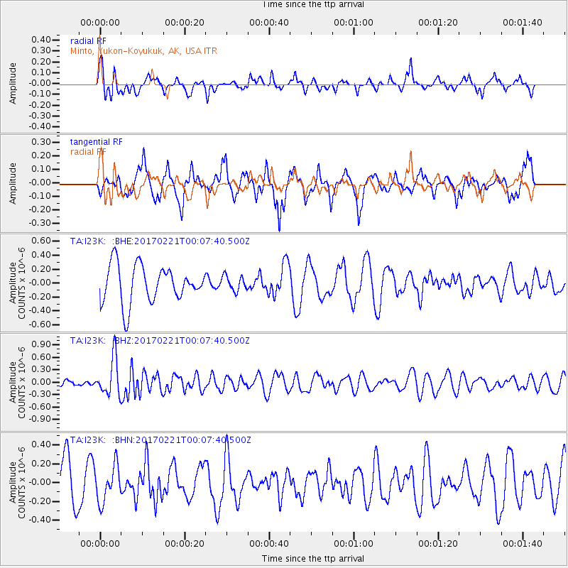
I23K Minto, Yukon-Koyukuk, AK, USA - Earthquake Result Viewer
*The percent match for this event was below the threshold and hence no stack was calculated.
| Earthquake location: |
Fiji Islands Region |
| Earthquake latitude/longitude: |
-15.0/-176.4 |
| Earthquake time(UTC): |
2017/02/20 (051) 23:55:48 GMT |
| Earthquake Depth: |
6.0 km |
| Earthquake Magnitude: |
5.5 Mww |
| Earthquake Catalog/Contributor: |
NEIC PDE/us |
|
| Network: |
TA USArray Transportable Network (new EarthScope stations) |
| Station: |
I23K Minto, Yukon-Koyukuk, AK, USA |
| Lat/Lon: |
65.15 N/149.36 W |
| Elevation: |
149 m |
|
| Distance: |
82.5 deg |
| Az: |
11.167 deg |
| Baz: |
206.289 deg |
| Ray Param: |
$rayparam |
*The percent match for this event was below the threshold and hence was not used in the summary stack. |
|
| Radial Match: |
41.58326 % |
| Radial Bump: |
329 |
| Transverse Match: |
42.60218 % |
| Transverse Bump: |
305 |
| SOD ConfigId: |
11737051 |
| Insert Time: |
2019-04-26 19:21:08.717 +0000 |
| GWidth: |
2.5 |
| Max Bumps: |
400 |
| Tol: |
0.001 |
|
Signal To Noise
| Channel | StoN | STA | LTA |
| TA:I23K: :BHZ:20170221T00:07:40.500Z | 3.558737 | 4.5940368E-7 | 1.2909177E-7 |
| TA:I23K: :BHN:20170221T00:07:40.500Z | 0.93735695 | 1.9528592E-7 | 2.0833677E-7 |
| TA:I23K: :BHE:20170221T00:07:40.500Z | 0.40707108 | 1.0894519E-7 | 2.6763186E-7 |
| Arrivals |
| Ps | |
| PpPs | |
| PsPs/PpSs | |


