You are here: Home > Network List > CI - Caltech Regional Seismic Network Stations List
> Station RPV Rancho Palos Verdes, California, USA > Earthquake Result Viewer
RPV Rancho Palos Verdes, California, USA - Earthquake Result Viewer
| Earthquake location: |
E. Russia-N.E. China Border Reg. |
| Earthquake latitude/longitude: |
43.6/130.4 |
| Earthquake time(UTC): |
1999/04/08 (098) 13:10:34 GMT |
| Earthquake Depth: |
566 km |
| Earthquake Magnitude: |
6.4 MB, 7.1 MW, 7.1 MW |
| Earthquake Catalog/Contributor: |
WHDF/NEIC |
|
| Network: |
CI Caltech Regional Seismic Network |
| Station: |
RPV Rancho Palos Verdes, California, USA |
| Lat/Lon: |
33.74 N/118.40 W |
| Elevation: |
64 m |
|
| Distance: |
80.8 deg |
| Az: |
51.891 deg |
| Baz: |
316.691 deg |
| Ray Param: |
0.046352033 |
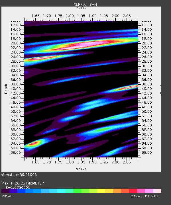
| Estimated Moho Depth: |
26.25 km |
| Estimated Crust Vp/Vs: |
1.68 |
| Assumed Crust Vp: |
6.048 km/s |
| Estimated Crust Vs: |
3.611 km/s |
| Estimated Crust Poisson's Ratio: |
0.22 |
|
| Radial Match: |
89.21008 % |
| Radial Bump: |
400 |
| Transverse Match: |
86.53492 % |
| Transverse Bump: |
400 |
| SOD ConfigId: |
3787 |
| Insert Time: |
2010-03-05 22:05:13.740 +0000 |
| GWidth: |
2.5 |
| Max Bumps: |
400 |
| Tol: |
0.001 |
|
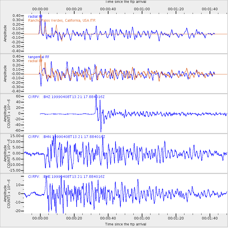
Signal To Noise
| Channel | StoN | STA | LTA |
| CI:RPV: :BHN:19990408T13:21:17.884016Z | 2.8433177 | 3.871809E-6 | 1.3617222E-6 |
| CI:RPV: :BHE:19990408T13:21:17.884016Z | 6.1648397 | 7.3505953E-6 | 1.1923416E-6 |
| CI:RPV: :BHZ:19990408T13:21:17.884016Z | 32.201916 | 2.0387732E-5 | 6.331217E-7 |
| Arrivals |
| Ps | 3.0 SECOND |
| PpPs | 11 SECOND |
| PsPs/PpSs | 14 SECOND |


