You are here: Home > Network List > CI - Caltech Regional Seismic Network Stations List
> Station RPV Rancho Palos Verdes, California, USA > Earthquake Result Viewer
RPV Rancho Palos Verdes, California, USA - Earthquake Result Viewer
| Earthquake location: |
Fiji Islands Region |
| Earthquake latitude/longitude: |
-21.4/-176.5 |
| Earthquake time(UTC): |
1999/04/13 (103) 10:38:48 GMT |
| Earthquake Depth: |
164 km |
| Earthquake Magnitude: |
6.4 MB, 6.8 MW, 6.8 MW |
| Earthquake Catalog/Contributor: |
WHDF/NEIC |
|
| Network: |
CI Caltech Regional Seismic Network |
| Station: |
RPV Rancho Palos Verdes, California, USA |
| Lat/Lon: |
33.74 N/118.40 W |
| Elevation: |
64 m |
|
| Distance: |
77.9 deg |
| Az: |
46.319 deg |
| Baz: |
233.967 deg |
| Ray Param: |
0.049615745 |
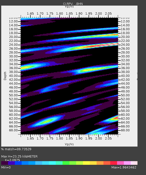
| Estimated Moho Depth: |
23.25 km |
| Estimated Crust Vp/Vs: |
2.10 |
| Assumed Crust Vp: |
6.048 km/s |
| Estimated Crust Vs: |
2.883 km/s |
| Estimated Crust Poisson's Ratio: |
0.35 |
|
| Radial Match: |
89.73529 % |
| Radial Bump: |
400 |
| Transverse Match: |
81.61309 % |
| Transverse Bump: |
400 |
| SOD ConfigId: |
3787 |
| Insert Time: |
2010-03-05 22:05:16.549 +0000 |
| GWidth: |
2.5 |
| Max Bumps: |
400 |
| Tol: |
0.001 |
|
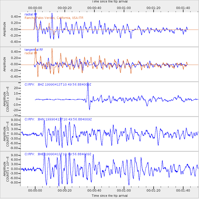
Signal To Noise
| Channel | StoN | STA | LTA |
| CI:RPV: :BHN:19990413T10:49:56.884009Z | 1.0326328 | 5.899277E-7 | 5.7128506E-7 |
| CI:RPV: :BHE:19990413T10:49:56.884009Z | 1.7636577 | 8.2959036E-7 | 4.703806E-7 |
| CI:RPV: :BHZ:19990413T10:49:56.884009Z | 3.823935 | 1.6326056E-6 | 4.2694387E-7 |
| Arrivals |
| Ps | 4.3 SECOND |
| PpPs | 12 SECOND |
| PsPs/PpSs | 16 SECOND |


