You are here: Home > Network List > CI - Caltech Regional Seismic Network Stations List
> Station RPV Rancho Palos Verdes, California, USA > Earthquake Result Viewer
RPV Rancho Palos Verdes, California, USA - Earthquake Result Viewer
| Earthquake location: |
Southeast Of Honshu, Japan |
| Earthquake latitude/longitude: |
32.8/140.4 |
| Earthquake time(UTC): |
2009/08/12 (224) 22:48:51 GMT |
| Earthquake Depth: |
53 km |
| Earthquake Magnitude: |
6.2 MB, 6.6 MW, 6.6 MW |
| Earthquake Catalog/Contributor: |
WHDF/NEIC |
|
| Network: |
CI Caltech Regional Seismic Network |
| Station: |
RPV Rancho Palos Verdes, California, USA |
| Lat/Lon: |
33.74 N/118.40 W |
| Elevation: |
64 m |
|
| Distance: |
80.7 deg |
| Az: |
55.926 deg |
| Baz: |
303.172 deg |
| Ray Param: |
0.048018735 |
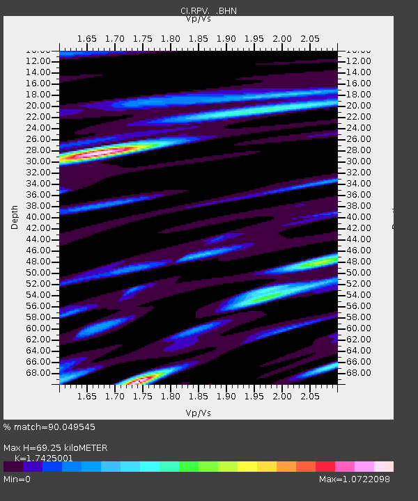
| Estimated Moho Depth: |
69.25 km |
| Estimated Crust Vp/Vs: |
1.74 |
| Assumed Crust Vp: |
6.048 km/s |
| Estimated Crust Vs: |
3.471 km/s |
| Estimated Crust Poisson's Ratio: |
0.25 |
|
| Radial Match: |
90.049545 % |
| Radial Bump: |
400 |
| Transverse Match: |
95.12331 % |
| Transverse Bump: |
400 |
| SOD ConfigId: |
2622 |
| Insert Time: |
2010-03-05 22:05:25.732 +0000 |
| GWidth: |
2.5 |
| Max Bumps: |
400 |
| Tol: |
0.001 |
|

Signal To Noise
| Channel | StoN | STA | LTA |
| CI:RPV: :BHN:20090812T23:00:27.701006Z | 28.054962 | 4.614783E-6 | 1.6449079E-7 |
| CI:RPV: :BHE:20090812T23:00:27.701006Z | 2.6524987 | 7.1200725E-7 | 2.6842886E-7 |
| CI:RPV: :BHZ:20090812T23:00:27.701006Z | 5.966301 | 1.8881277E-6 | 3.1646536E-7 |
| Arrivals |
| Ps | 8.7 SECOND |
| PpPs | 31 SECOND |
| PsPs/PpSs | 39 SECOND |


